Showing posts with label Sligo. Show all posts

Wednesday, November 25, 2020

Ballaghaderreen to Kilfree Branch Line – A Brief History


Ballaghaderreen Railway Station

            Many excellent photographs of the now closed Ballaghaderreen to Kilfree Junction branch line have appeared on Facebook recently. I grew up close to Edmondstown Station and have happy memories of travelling on the line.

On Saturday, 6th December 1862 the prospectus of the Sligo and Ballaghaderreen Junction Railway (S&BJR) was published. The following year plans for the proposed branch line were presented to the Parliament at Westminster. The bill became law when Queen Victoria affixed her signature to the relevant documents on the 13th July 1863.

The Sligo & Ballaghaderreen Junction Railway was authorised to build a branch line connecting Ballaghaderreen to the newly opened extension of the Midland Great Western Railway (MGWR) from Longford to Sligo. On 31st October 1874, an advertisement was issued by the MGWR announcing the opening of the branch line on 2nd November.

Opened in 1974

The new railway line opened as planned in 1874, just five years before the apparition at Knock, Co Mayo, in 1879 and was operated by the Midland and Great Western Railway. It cost £80,000 to build. The first train from Kilfree to Ballaghaderreen was driven by Ben Partridge, an English man from Kent, who married and settled down in the town.

However, after trading at a loss for two years, the S&BJR sold its interest in the line to the Midland Great Western Railway for £24,000 in 1877. The Sligo and Ballaghaderreen Junction Railway lost its identity and was absorbed into the Midland system.

Route

The distance from Ballaghaderreen to Kilfree Junction was nine miles. The speed restriction was 25mph and half an hour was the time allowed. There were two intermediate halts on the branch line - Edmondstown and Island Road. Excellent views of Lough Gara were visible between Island Road and Kilfree Junction.

Service

Dublin - Ballaghaderreen Railway Timetable

            The basic passenger service was three or four round trips per day apart from the “Emergency” when the service was reduced to one round trip. Between 1947 and the line’s closure in 1963, the service decreased to two round trips in the morning and early afternoon. Most services were mixed passenger and freight.

Ballaghaderreen Station

The stone-built station building at Ballaghaderreen still exists but is in a very derelict state. Part of the platform also survives. The goods shed, used by the GAA, remains complete with its typical long cattle bank platform.


Edmondstown Station

Edmondstown Station c1960

Opening in November 1874, Edmondstown Station had a single storey station building, complete with an attached waiting room. The station only had one platform and an adjacent level crossing.

 Island Road Station

Island Road Station

            Island Road railway station opened on 1 July 1909 and consisted of a station masters' house and small waiting room. The station was situated next to the gated level crossing on Island Road in the townland of Tawnymucklagh, and about 1/2 mile from the village of Monasteraden. The station is now in use as a private residence, with the waiting room, station house and platform largely intact.

Kilfree Junction

Kilfree Junction

            Kilfree Junction was located on the Sligo line in the townland of Cloontycarn between Boyle and Ballymote. The station was not located near any significant settlement, the nearest, Gorteen in County Sligo, being over 6km away. The station had three platforms: two served a passing loop on the main line and the third was used by the branch line. The station had sidings and turntable for turning round engines coming from the branch line. There was a signal box and a house for the station master.

Incidents

            During the Irish War of Independence (1919 – 1921) trains were regularly stopped on the branch line by the IRA, British soldiers, and the Royal Irish Constabulary (RIC). In May 1921, a train was hi-jacked and used to shoot at the RIC Barracks in Ballaghaderreen

Blizzard

The blizzard of 1947 was one of the most memorable episodes of the history of the Branch Line. The Railway system north and west of the Longford was snowbound. Ballaghaderreen town and district was isolated, with snow piled up to ten feet high on the roads. After several days and the threat of a food shortage, a snow clearance committee was organised. A group of 150 men boarded the train at Ballaghaderreen and working in relays proceeded to clear the snow from the line.

Post War

After the Second World War, better main roads, and an increase in road transport for transporting goods led to financial problems for the Railway system. Eventually, the Railway Company was obliged to reduce spending and resorted to a reduction of its service on uneconomic routes. The tragic news of the looming closure of the Ballaghaderreen to Kilfree line was delivered to the people of Ballaghaderreen. Organised protest against the closure was unsuccessful and the line finally closed on 2nd February 1963.

Closed in 1963

Train about to depart Ballaghaderreen Station for Kilfree Junction

            The last return passenger trip departed Ballaghaderreen at 11:50 on 2nd February and was hauled by 0-6-0 steam locomotive 574. I joined the 160 children and 30 adults who made the journey marking the sad end of an era. The train was seen off by as many spectators. The return journey from Kilfree Junction started with the bang of detonators and a local band played a farewell tribute. The last train was a special cattle train hauled by Locomotive B133 leaving Ballaghaderreen at 15:22.

Monday, August 31, 2020

Carrowmore Megalithic Cemetery Revisited


Listoghil
Carrowmore Megalithic Cemetery

More than 6,000 years ago, the Stone Age peoples of Western Europe began to build stone monuments over their dead as tombs and ceremonial places. This was the beginning of what has become known as the megalithic tradition of the Neolithic period. In 2013, I wrote a blog post about Carrowmore Megalithic Cemetery, Co. Sligo in Ireland. This is one of four major passage tomb cemeteries in Ireland, along with Carrowkeel, Brú na Bóinne and Loughcrew.

 Approximately 60 such monuments are recorded in the complex, but many others were destroyed by quarrying and agricultural activities over the past two centuries. In 2019 archaeologists from IT Sligo, led by Dr. Marion Dowd and Dr. James Bonsal, investigated one of the less known monuments, classified in the Sites and Monuments Record as a barrow. They set out to establish the date and nature of the monument and its relationship to passage tombs within the complex.

Listoghil and Meascán Mhéabha

The largest monument in the cemetery is a cairn known as Listoghil. This monument is also notable for being the only one at the site that is known to have been decorated with megalithic art. It is also the only tomb in the cemetery where both cremations and inhumations have been found although cremation was the norm.

Inner Chamber
Listoghil

Archaeologists have found that the rest of the tombs were arranged in a roughly oval shape around Listoghil, suggesting that this may have been the focal point of the cemetery. Overlooking the complex to the west, is Knocknarea Mountain on the summit of which is the passage tomb of Meascán Mhéabha, otherwise known as Queen Maeve’s Grave. (Photo)

Latest Investigation

The monument investigated consists of a broad, shallow ditch, circular in plan, with an overall external diameter of approximately 20m. The ditch is 2.9m wide at the top and 0.8m deep. A layer of densely packed stones formed the base along the north-eastern side. There was no evidence of a bank either inside or outside the ditch. The excavation revealed an inner circular, area approximately 8m in diameter, that consisted of several overlapping deposits of stones.

The earlier identification of the monument as a Bronze Age or Iron Age barrow has been revised in view of the central circular deposit of stones and the absence of a bank. Various ideas about what the monument represented were discounted based on the excavation results and geophysical information. However, archaeologists concluded that it was not a barrow and was almost certainly prehistoric in date. Whilst the precise purpose of the monument remains unclear it was probably ritual/funerary in nature.

Artefacts

The excavation did not produce any animal bone, human bone, or charcoal fragments. Archaeologists found many prehistoric tools known as cherts which were crucial to prehistoric societies. For example, they would have been used for a variety of tasks, such as making baskets, working bones, scraping hides and in the preparation of food. This area outside the monument produced over 200 finds of post-medieval and modern date, including shards of glass, potsherds, and clay pipe fragments.

Dating Evidence

Archaeologists believe that different type of lithics and their condition represented multiple events and time periods possibly from the Mesolithic through to the Bronze Age. Similar material has been recovered from other sites in the Carrowmore complex. The chert convex scrapers are like those found at Neolithic hut sites on Knocknarea Mountain.

It was not possible to carry out radiocarbon dating due to the lack of suitable organic material. Optically Stimulated Luminescence (OSL) dating, which calculates when a sediment was last exposed to sunlight, produced a date of 4050–2850 BC.

Conclusion

In the past, the focus of archaeological research at Carrowmore has been on the passage tombs. This recent work has produced a Neolithic date for what is an unclassified monument located at the centre of an important megalithic cemetery. The lithics indicate multiple periods of activity at the monument during the Neolithic, and possibly also the Bronze Age. Researchers acknowledge that the ditch may not be contemporaneous with the central stony area.

Earlier work by Stefan Bergh and Robert Hensey’s produced 25 dates from monuments known as Carrowmore 3 and 55a, revealing the Middle Neolithic as the principal period of use of these two monuments. The OSL date from this excavation is consistent with this period.

Archaeologists believe that the central location of the Neolithic circular ditched monument at Carrowmore suggests that it was a site of significance within this highly ritualised funerary landscape. It is one of a small number of monuments on the elevated plateau which also commands impressive views of the huge passage tombs of Listoghil and Meascán Mhéabha.

The excavation failed to find evidence of a boulder circle or a central structure such as a dolmen or cist. Several aspects of the site bear a resemblance to features of the passage tombs excavated by Burenhult. Deposits of densely packed stone were noted at several passage tombs, occurring between the outer circle of boulders and the central chamber.

For more information see:

The Carrowmore Conundrum Author(s): Marion Dowd and James Bonsall Source: Archaeology Ireland. Vol. 34, No. 1 (Spring 2020), pp. 21-25 Published by: Wordwell Ltd.

https://www.blogger.com/blog/post/edit/7447788106874258351/5663729884492012271

https://www.ancient-origins.net/news-history-archaeology/mysterious-monument-carrowmore-0012143

https://www.youtube.com/watch?v=0dwfsrfvKo0

https://www.youtube.com/watch?v=gZYdtDUH-0Y

https://www.youtube.com/watch?v=pn3PNFkRqJE

Thursday, February 22, 2018

Streedagh Strand – Spanish Armada Shipwrecks

Streedagh Strand Memorial
Photograph (c) Richard Golden

Streedagh Strand is peaceful and quiet now. The cries of those souls who tragically perished there are no longer heard and over four centuries of tides have washed away their blood.
In September 1588 three ships of the Spanish Armada were wrecked off Streedagh Strand on the coast of Sligo. They were caught in a sudden violent storm that raged over a three-day period, culminating in the destruction of the ships and the loss of over 1,000 lives. The ships were La Lavia, of Venetian origin, Santa Maria de Visóri from Ragusa (Dubrovnik) and La Juliana from Barcelona.
In 1985, a group of English divers - known as the Streedagh Armada Group (SAG) - discovered the wrecks. Following some investigative work at the time, many artefacts were recovered, including three guns from the wrecks of La Juliana and one from La Lavia.
Protracted legal proceedings involving the State and Streedagh Armada Group finally determined that ownership of the three wrecks was vested in the State.

La Juliana
Streedagh Strand
Photograph (c) Richard Golden
In 2015 the Underwater Archaeology Unit (UAU) investigating the wreck of the La Juliana identified five bronze guns and one possible iron gun lying exposed on the seabed. Five carriage wheels and two large anchors were also visible. Four more large gun-carriage wheels were also recorded, bringing the total number to nine, one of which was recovered. A partially buried bronze cauldron was also recovered which contained the remains of pitch indicating that it was used on board for repair work to the ship.
Bronze Canons from the Spanish Armada Wreck La Juliana
Streedagh Strand - photo from Flickr
Nine ornate bronze guns of various calibres were recovered from the wreck site of La Juliana. All these items were in remarkable condition with crests, embossed figures of saints, the date of production, weight details within scroll motifs and makers' symbols perfectly preserved. Seven of the guns recovered show the year of manufacture as 1570. The saints depicted, many martyred, span several centuries, from Roman times through to the medieval period.
The La Juliana was engaged as a transport vessel in several key battles. This ship took part in the Battle of Lepanto in 1571, when the coalition of European Christian maritime states brought together by Pope Pius V destroyed the Muslim fleet of the Ottoman Empire off the western coast of Greece. The ship carried 32 guns during the 1588 Armada campaign with a complement of 325 soldiers and a crew of 70 men.

The Spanish Armada
 Phillip 11, the Catholic King of Spain,
In the second half of the sixteenth century many of the countries of Europe were embroiled in wars that had their origins in the religious upheavals which had followed the Reformation. A state of undeclared war existed between England and Spain at the time of the Armada. The assembling of this great fleet by Phillip 11, the Catholic King of Spain, and its purpose appears to have been the worst kept secret in Europe. The situation came to a head with the execution of Mary Queen of Scots in February 1587, and with the attack on Cadiz by Sir Francis Drake in April of the same year. It was then that preparations began for the great Armada of 1588.
The fleet arrived off the Lizard on July 29th. An English fleet of 90 ships sailed south to meet the Armada. On the night of August 7th, the English sent fire ships in amongst the Spanish fleet. This was a dreaded tactic as the ships were filled with explosive and incendiary materials. In panic, the Spaniards were forced to abandon the venture. The Spanish ships were given instructions to sail home via the East coast of England, around the north of Scotland and Ireland before turning southwards for Spain.
Streedagh Strand
Photograph (c) Richard Golden
Of the original fleet of 130, up to 26 ships may have been lost around the coast of Ireland, and possibly as many as 40 in all were lost on the return journey to Spain. The human cost of the expedition was high: some 1,913 soldiers and 1,016 sailors lost their lives.
Captain Francisco De Cuellar, a survivor, wrote a fascinating account of the wrecking of these three ships and the subsequent events. De Cuellar describes the dreadful conditions of the wrecking and the terrible loss of life, one thousand drowned and those survivors who reached the shore being stripped and robbed by the local "savages".
Following the defeat of the Armada, Elizabeth had medals struck with the legend, "God breathed and they were scattered". The devout Phillip was heard to comment on hearing of the failure of the Armada, "I sent my ships to fight against men, not the winds and tides of God".

Conclusion
The wreck of La Juliana is significant for many reasons. It was a Catalan-built ship, which is critical, as we have very little knowledge of ship construction and the Iberian shipbuilding tradition in this period. The La Juliana provide an opportunity to gain further insight into one of the wrecks from Armada campaign. It provides the most complete collection of bronze guns recovered from any Spanish Armada ship to date.
The diversity of the bronze cannon and the details on each one makes them national treasures. The variety and size of cannon shot will provide further information on the types of gun carried on board ships like La Juliana and the type of the munitions supplied for such a campaign.
The use of the fire-ships and the subsequent orders to the Armada to return to Spain were turning points in European history. If the wind had changed direction and blown the fire ships away from the Armada at Calais we might all be speaking Spanish today.

For further information see:
(1) CANNONS, SAINTS AND SUNKEKL SHIPS—AN ARMADA WRECK REVEALED Author(s): Fionnbarr Moore, Karl Brady and Connie Kelleher Source: Archaeology Ireland, Vol. 29, No. 4 (Winter 2015),
(2) The Irish Legacy of the Spanish Armada Author(s): Laurence Flanagan Source: Archaeology Ireland, Vol. 2, No. 4 (Winter, 1988)
(3) Finds of the Spanish Armada Author(s): Cormac F. Lowth Source: Dublin Historical Record, Vol. 57, No. 1 (Spring, 2004)
 http://www.sligoheritage.com/ArchSpanishArmada.htm
https://www.youtube.com/watch?v=j5MYIQKs7Gc   
 https://www.youtube.com/watch?v=a_6nxyarrog
https://www.youtube.com/watch?v=pK1BH28nhZA
https://www.youtube.com/watch?v=OkypWnFIBA8


Thursday, January 25, 2018

Neolithic Remains found in Co. Mayo

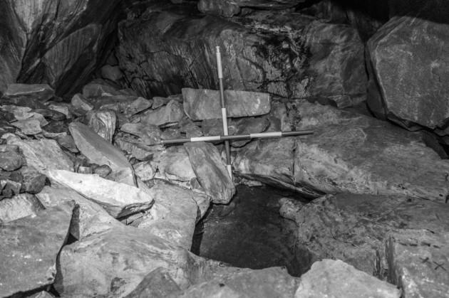
Ancient human remains found in Mayo date back over 5,000 years. Local hillwalker, Michael Chambers, came across the human bones in a rock-cut chamber among massive boulders in August 2016, while walking on Ben Gorm Mountain in the Nephin Beg range of west Mayo. The National Monuments Service, in consultation with the National Museum of Ireland, commissioned a rescue excavation, carried out by Dr Marion Dowd of IT Sligo.

Researchers concluded that the natural boulder chamber in which the remains were found was used for human burial practice during the Neolithic period. A least 10 individuals were placed in the chamber over a period of up to 1,200 years. One of the adult bones was dated to 3,600 BC, while a bone of a child skeleton dated to 2,400 BC.

Ben Gorm Mountain, Mayo
Image: T Kahlert via Department of Culture

Archaeologists believe that bodies were brought into the cave chamber and laid out in a pit. At some later stage, the skulls might have been deliberately broken as part of a complex burial ritual and the larger bones removed.

 “Large pieces of quartz had been placed in and around the bones. When the radiocarbon dates came through it was very exciting. Not only were the bones Neolithic, but the dates showed the site had been used for over 1,000 years,” Dr Dowd said.

Dr Dowd points out that it was not a burial site as such, but a ritual place where bodies were placed to decompose. Only a very small proportion of each skeleton was found, with most of the bones apparently deliberately removed.

 Pit in the cave which contained human remains after the excavation
Image: T Kahlert via Department of Culture

The Neolithic period was a time of change with a move from hunting and gathering to a more settled way of life associated with the beginnings of agriculture. Burial practices in this period entailed interment in large, highly visible monuments, and by ritual practices resulting in the scattering of human bones. These monuments were frequently built in the densely populated regions of the Mesolithic Period and may have been markers between the new and old peoples. They signified a lasting link between the community, the ancestral dead, and the land which they occupied.
It has been suggested that the shape of these ancient tombs is related to the type of housing favoured in an area (round, rectangular, trapezoid or irregular. Large communal monuments for the dead began to appear on the coastal fringes of Western Europe during this period.
More than 6,000 years ago, the Stone Age peoples of Western Europe began to build stone monuments over their dead as tombs and ceremonial places. This was the beginning of what has become known as the megalithic tradition of the Neolithic period.
The first small passage tombs on the summit of Knocknarea, Co. Sligo, were probably built in the first half of the fourth millennium BC, physically marking out the ritual significance of the place. A few hundred years later, the sacred space was defined by a complex system of banks along the eastern side of the mountain. The cairn known today as Miosgán Meadhbha (the legendary burial place of Queen Maeve) was probably built around this time and most likely covers a passage tomb.
High up on the north-western slopes of Knocknarea there are a number of natural caves, and in two of them human remains of Neolithic date have been found. These may have been places used for defleshing of the dead.  The caves might have played a role in the rituals linked to the monuments on the summit.
New insights into the funerary practices in ancient Ireland are being provided through studies led by a researcher at the Department of Anatomy at New Zealand's University of Otago.  The project applies modern techniques and research questions to human remains that were originally excavated more than 100 years ago. Researchers, lead author is Dr Jonny Geber, focuses on the 5000 years-old Passage Tomb Complex at Carrowkeel, also in County Sligo. This site is one of the most impressive Neolithic ritual landscapes in Europe.

Two of the tombs at Carrowkeel, Ireland. ( public domain )

             The team analysed bones from up to seven passage tombs that included both unburnt and cremated human remains from around 40 individuals. Dr Geber and his colleagues found that the unburnt bone displayed evidence of dismemberment.

"We found indications of cut marks caused by stone tools at the site of tendon and ligament attachments around the major joints, such as the shoulder, elbow, hip and ankle.”

According to Dr Geber, the new evidence suggest that a complex burial rite was undertaken at Carrowkeel, that involved a funerary rite that focussed on the "deconstruction" of the body.

"This appears to entail the bodies of the dead being 'processed' by their kin and community in various ways, including cremation and dismemberment. It was probably done with the goal to help the souls of the dead to reach the next stages of their existence."

This study shows that the Carrowkeel complex was probably a highly significant place in Neolithic society in Ireland, and one which allowed for interaction and a spiritual connection with the ancestors. The evidence suggests that the people of Neolithic Ireland may have shared similar beliefs and ideologies concerning the treatment of the dead with communities beyond the Irish Sea, according to the researchers, Dr Geber says.

Monday, December 7, 2015

Carrowntemple - Early Christian Enclosure

Grave Slab 2 - Carrowntemple
My recent posts dealt with Boyle and Cloonshanville Abbeys so I thought I would continue the monastic theme by including the early Christian site at Carrowntemple, near the village of Gurteen, Co Sligo, in my blog. There is an excellent piece about this early church on the Lough Gara Lakes and Legends website.

There were originally two enclosures around the Carrowntemple complex but both are now partly demolished. The area of the inner enclosure is 0.4 ha. (1 acre) while the outer enclosure has an area of 6 ha. (15 acres). At the centre of the inner enclosure are the remains of a plain medieval parish church measuring 9.40m by 6.40m still standing 3.10m high. This church is probably on the site of earlier wooden churches going back in time to the foundation of the monastery. The church had a single-light east window.

Grave Slab 3 - Carrowntemple
Souterrains or underground chambers to the west of the church ruins would have been used for storage and refuge in times of trouble.

Over the years fourteen stone grave slabs, dating from the early Christian period, were found mainly to the south and east of the church within the old graveyard. In 1984 five of these slabs were removed from the graveyard. These were recovered in 1986 and, later that year, the remaining exposed slabs on site were taken into care by Sligo County Council.

Grave Slab 5 - Carowntemple
Between 1990 and 1992 Cillian Rogers made replicas of the slabs for the Council and these are well worth a visit. The finance for this project was provided by the National Heritage Council. Two of the original slabs have been on display in the National Museum of Ireland.

Martin Timoney, archaeologist, states that the Carrowntemple grave slabs are surprising in two ways:

“Firstly, how so many superb slabs did not come to archaeological notice until 1973 is simply amazing. Secondly, some of the designs are outstanding, even unique, for many reasons.”

Moylough Belt-Shrine
He points out that two of the slabs (No’s. 2 and 3), bear art of the Early Christian period that is derived from the Celtic art of the preceding Pagan Iron Age. One of these is very close to a design in the book of Durrow and is datable to c. 650 AD. Several of the panels of the seventh century Moylough Belt-shrine, found only a few miles west of Carrowntemple, have this same mix of Pagan and Christian artwork. Some of the slabs are linked by their designs and so a 7th and 8thcentury date has been accepted for many of the slabs.

Grave Slab 6 - Carrowntemple
Half of a cylindrical plinth stone, thought to have been used to hold erect the double-sided No 10 slab was found. The designs are considered to be much more elaborate than those of any other Co Sligo grave slab of the period with the exception of those on Inishmurray. On slabs 3,4,5,6,8 and 11 it is the band and not the groove that forms the design.

The Carrowntemple grave slabs raise interesting questions about the transition between pagan Ireland and the arrival of Christianity. Edel Bhreathnach’s excellent book “Ireland in the Medieval World AD 400-1000” provides some valuable insights into this period.

The coming of Christianity to the island is traditionally linked to St. Patrick, who is said to have converted the Irish during the early fifth century. However, Palladius was sent by Pope Celestine a year earlier in AD431, to minister as bishop ‘to the Irish believing in Christ’. Scholars believe that the existence of Christian communities in Ireland was known to Rome at this time.

Patrick left an account of his mission in two important Latin documents, his Confessio, which was a defence of his mission against critics in Britain, and his Epistola, a letter condemning a British king, Coroticus, for attacking and enslaving some of his newly converted Christian flock.

Christianity in early medieval Ireland was administered by bishops, priests and abbots, some in orders, others who were lay people. All kinds of church buildings were constructed from simple post and wattle structures to larger stone churches and monumental enclosures.

The two prevalent burial types in Ireland from the late centuries BC and early centuries AD were cremations and inhumations, with the former more prevalent in the early period and inhumation becoming common into the first millennium AD.  Interestingly, cremation did not become obsolete, and instances of this practice have been dated to as late as the eight century.

For Christian and non-Christians alike, death, burial, and the subsequent treatment of the dead, were purely matters for the family. The Christian clergy were not involved at all and pagans and Christians were buried alongside one and other in family graves.

However, during the fifth and sixth centuries, burial practices for the nobility - clerics, kings and other aristocrats – began to change. This was due to what has been described as the cult of saints. Early Christians believed that by being buried near a holy grave they could hope to stand beside the saint on the day of the resurrection. The practice of burying people inside city walls developed, so that they could rest near the altars of urban churches.

Grave Slab 10 - Carrowntemple
Irish society of the early medieval period very gradually progressed from ancestral and familial rites to rites and cemeteries controlled by the church. Often these practices were not mutually exclusive. Some non-Christian funerary customs continued to be practised, including burial in cemeteries not obviously associated with a church.

It is not until at least the eight century, when the church exerted its influence more widely, that it is possible to classify with some certainty the difference between a Christian and non-Christian burial or cemetery.

The Christian rituals most prominent in St. Patrick’s Confessio and Epistola are the rites of baptism and confirmation which were rites of passage and initiation. Christian baptism, conferred a new identity on Patrick’s followers that, in the fifth century, would have probably set them apart from their own society, thereby, creating a community within a community.

Scholars believe that wells were used instead of baptisteries in Ireland, which may explain the proliferation of holy wells throughout the country. Holy wells are thought to have been sacred places in pre-Christian times and may have continued to be associated with non-Christian rituals.
 St Attracta's Holy Well - Clogher


Carrowntemple, with its intricately carved Early Christian grave slaps derived from the Celtic art of the preceding Pagan Iron Age, offers a glimpse of the intersection of these two important periods in the history of Ireland.


For further information please see:
Bhreathnach, Edel, ‘Ireland in the Medieval World AD 400-1000’ (Four Courts Press 2014)
http://www.loughgaralakesandlegends.ie/carrowntemple-grave-slabs

Saturday, May 2, 2015

Silence in Court - Creevykeel Court Tomb


Creevykeel Court Tomb - County Sligo
Hidden behind a tall hedge on the busy Sligo to Bundoran road lies the Creevykeel Court Tomb. There, the casual visitor will find what looks like a low elongated pile of stones of varying sizes some of which have been deliberately positioned. However, there is much more to this ancient site than meets the eye.
More than 6,000 years ago, the Neolithic or New Stone Age peoples of Western Europe began to build stone monuments over their dead as tombs and ceremonial places. This was the beginning of what has become known as the megalithic tradition of the Neolithic period.
Creevykeel Court Tomb is amongst the finest examples of its type in Ireland. It dates from the Neolithic Period, 4000-2500 BC and was excavated in 1935 and then restored. The monument is located on the foothills of Tievebaun Mountain close to the sea near Mullaghmore in County Sligo. The old name for Creevykeel is Caiseal a' Bhaoisgin, the Fort of Bhaoisgin, Bhaoisgin being the well near the cairn.
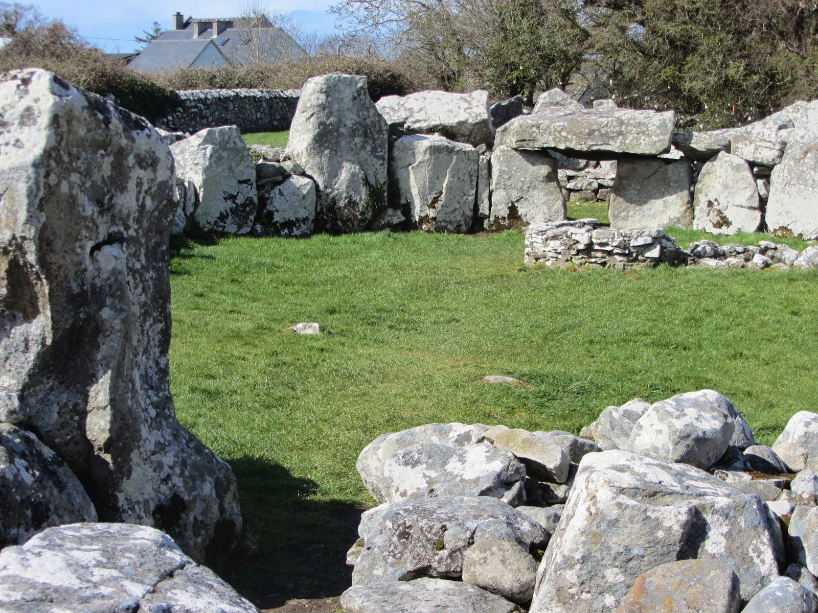
The cairn measures 55 x 25 meters, with the wide edge to the east and tapers away to a tail at the west end. The actual court itself, which is enclosed by the cairn, is oval in shape measuring 15 x 9 meters. It is lined with large boulders that rest on the surface rather than sunk into the ground. The main body of the cairn was originally surrounded by a stone revetment to hold the mound together.
A narrow entrance passage, lined with large boulders and approximately 4.5 m in length, leads from the east end to the court. There is a two-chambered gallery to the north west of the court. Three smaller chambers can be seen at the western end of the monument, two on the north side and one on the south side. These are quite different to the main chamber, and are considered by some archaeologists to be small passage graves.
Court with Christian Feature top right
Large areas of the court were paved with small flat slabs while in places, cobble stones and sea sand from the nearby shore was also found. Archaeologists found evidence of large fires within this enclosed area as well as fragments of cremated bone and charcoal. The standing stones (orthostats) around the court are quite massive chunks of local sandstone. They get larger approaching the opening at the rear of the court, which gives access to an inner chamber, now roofless but which was originally covered with massive corbels, making an artificial cave.
It is unclear whether the eastern end was originally the higher as well as the broader, as is generally the case with these monuments. However, the excavation showed that the builders had used the natural slope of the ground to obtain the effect of height at this end.
Court-tombs date from the Neolithic Period and are found mainly in the northern half of the country. Most of these sites are to be found north of a line extending from Dundalk to Galway. Their most distinctive feature is the ceremonial court which is set in front of a gallery or galleries divided into two or more burial chambers.
The court usually occupies one end of a long cairn but sometimes there are courts and chambers at both ends of the cairn. In other examples, as in the case of Creevykeel, the court is completely enclosed within the cairn and is of circular or oval shape, access being gained through a short narrow passage leading to the front of the cairn.
These megalithic monuments usually had two functions: the chamber to serve as a tomb, and the courtyard to accommodate some form of ritual. Objects were often buried with the deceased, as the first Neolithic farmers believed in life after death.
Excavations at Creevykeel uncovered four cremation burials, decorated and undecorated Neolithic pottery, flint arrow heads, polished stone axes, a flint knife, stone bead, four blue glass beads, a small bronze broach and stud, part of a red deer antler handle, part of a comb and other artefacts, including a clay ball.
Over 133 stone axes alone have been discovered along the shores of Lough Gara. Stone axes are normally ascribed to both the Mesolithic and the Neolithic periods. Polished stone axes, however, seem to appear first in the Neolithic while ground axes can belong to the Mesolithic or Middle Stone Age. These tools were used for cutting, shaping and dressing wood. A small polished stone axe was also found during excavation of the Drumanone Portal Tomb close to Lough Gara.
Kiln from Early Christian Period
Inside the court area archaeologists discovered a kiln dating from the Christian Period together with evidence of iron-smelting. Iron Age and early Christian metalworkers seem to have liked working in ancient sites including crannogs. Such ancient sites may, perhaps, have held magical properties in relation to metalwork.
Archaeologists excavating a crannog at Lough Gara in the townland of Sroove found a small bowl-shaped depression that may represent the shape of a small bowl-furnace for iron-smelting. Nearby, was found remains of slag, some pieces of which had the red clay remains of the furnace attached to them. 
Creevykeel Court Tomb remains one of the best examples of its type in Ireland and is well worth a visit if you happen to be in that part of North Sligo which has a rich megalithic tradition.

Saturday, June 28, 2014

Carrowkeel Megalithic Cemetery - County Sligo

Lough Arrow viewed from
Carrowkeel Megalithic Cemetery
Carrowkeel Neolithic or New Stone Age passage tomb cemetery is situated in south County Sligo, near the village of Castlebaldwin.  The tombs are between 5400 and 5100 years old (3400 to 3100 BC), and predate the Pyramids of Egypt's by 500-800 years. Carrowkeel is one of four major passage tomb cemeteries in Ireland (the other three are Brú na Bóinne, Lough Crew, and Carrowmore). A total of 14 tombs have been recorded in this cemetery. Six more passage tombs are located close by in what archaeologists call the Keshcorran complex.

A passage tomb consists of a narrow stone-lined passage leading to a chamber. Other smaller chambers may open off the main chamber. The passage and chambers are roofed with capstones but larger chambers tend to be corbelled. A round cairn covers the actual tomb and the cairn is usually surrounded by kerbstones.

The mountain range containing Carrowkeel Cemetery is called the Bricklieve Mountains, which means the speckled mountains in Irish. This may refer to their appearance when more quartz rock survived on the outside of the cairns, causing them to sparkle in the sun. The Carrowkeel cairns are built on hilltops at altitudes between 240 and 360 meters.  

A common feature of Irish cairns is that the passage of one monument is frequently oriented to another prominent cairn, as well as the rising or setting position of the sun and moon. This occurs at several of the Carrowkeel cairns. For example, Cairn B opens towards Knocknarea and ruined Cairn M is oriented to Kesh Cairn. The tombs were largely intact when rediscovered and hurriedly excavated in 1911. The cairns were designated at this time by letters and this naming convention remains today.

Archaeologists do not know what ritual function, in addition to acting as burial places for the dead, the passage tombs served for these cultures. A reverence for the sun is suggested by the alignment of many of the passages to the rising or setting of the sun on yearly solstice or equinox events.

The Cairns

Three Cairns at Carrowkeel
Photo: bettlebrox - www.flickr.com
Cairn B is 22 metres in diameter, making it one of the larger cairns in the Bricklieve group. The passage is about 3 metres long and widens to a small chamber. The entrance is high up in the body of the cairn. In 2010 a local archaeologist discovered the first panel of megalithic art recorded at Carrowkeel consisting of two small spirals.

Cairn F is the largest and most important of the cairns at Carrowkeel. It has a diameter of 26 metres and probably stood 8 - 10 metres high. The cairn contains a very large well-built chamber formed from massive squared limestone slabs with five compartments, two at each side and an end recess. The passage is about 8m long.

Cairn G is the best preserved of the Carrowkeel monuments and is a fine example of a cruciform Irish Passage Cairn. It is a classic Irish passage tomb, consisting of a short passage leading to a central chamber with three equally spaced side chambers. The most interesting feature of this tomb is the roofbox situated above the entrance.  The sun enters the chamber through the roofbox at sunset around the summer solstice and illuminates the back of the chamber. The only other known roofbox was discovered at Newgrange .
Cairn G showing roofbox

Carrowkeel Cairn G is estimated to be 700 years older than Newgrange and is smaller and less sophisticated. The passage is two meters long compared with nineteen meters at Newgrange.

Cairn K was also constructed with the classic cruciform shaped chamber and has an intact dry-stone corbelled roof. The 7 metre-long passage is orientated to Queen Maeve's Cairn on the top of Knocknarea. It has a diameter of about 21 meters, is some 6 meters high, and is surrounded by a thick layer of bog, which has covered any kerbstones. The items found during the excavation of Cairn K in 1911 were typical of the finds in the other cairns: pieces of the Neolithic pottery, known as Carrowkeel Ware since that time; cremated human remains, chalk balls, antler pins and pendants.

Hut Sites

Nearby, at Mullaghfarna, archaeologists have identified more than 150 small stone lined hollows with entrance features which are believed to be Neolithic huts or enclosures.  Their circular stone foundations, with diameters ranging from 8 m to 18 m, still mark the spots where the tent-like huts stood. These hut sites may date from the third millennium BC. In 2003, trial excavations at three of the sites produced finds from the Neolithic/Bronze Age including:  chert scrapers, a flint knife, fragments of cremated bone, decorated pottery and charcoal. Similar objects were discovered during the excavation of hut sites on Knocknarea in 2000.

This prehistoric village is likely to have been connected to the Carrowkeel cairns and may have housed the workers who built the passage tombs, or perhaps their descendants, who attended some ancient ritual there.

Conclusion

The earliest evidence we have for human occupation in Ireland dates from around 8000 BC. For the next 4000 years our ancestors survived by hunting, fishing and gathering wild plants. The gradual introduction of farming to Ireland around 4000 BC brought domesticated cereals and animals from Britain and the European mainland. Shortly after this time, people began to build megalithic tombs such as those at Carrowkeel, Carrowmore, Kesh and Knocknarea.

All told, there are 27 passage tomb monuments in the Carrowkeel-Keshcorran Complex, a total that includes three monuments located nearby but not in the Bricklieve Mountains. Archaeologists do not know what ritual function these passage tombs served, in addition to acting as burial places for the dead, for these cultures. The alignment of many of the passages to the rising or setting of the sun on yearly solstice or equinox suggests reverence to the sun. The presence of items not normally associated with the everyday life of these people and also the discovery of prehistoric art also point to a ritual function for these sites.

Saturday, March 8, 2014

Archaeologists find bones of a Stone Age child and an adult in tiny cave

Knocknarea Mountain with Maeve's Cairn on Top
The Irish News edition of 28th February 2014, reported that archaeologists at IT Sligo had found bones of a Stone Age child and an adult in a tiny cave high on Knocknarea Mountain. Radiocarbon dating has shown that they are 5,500 years old, which makes them among the earliest human bones found in the county. While this discovery is very exciting it is not entirely surprising, given the rich archaeological heritage of the county. The find provides important new evidence of Knocknarea’s Neolithic past and a prehistoric practice known as “excarnation” or de-fleshing.

Researchers discovered a total of 13 small bones and bone fragments in an almost inaccessible cave in November 2013. Three of the bones were from the child aged 4 to 6 years and 10 were from an adult aged 30 – 39 years. They included foot bones and fragments of skull. It was not possible to establish gender.

Archaeologists believe that the adult had been placed in the cave about 300 years before the child, who died about 5,200 years ago. The small number of bones and their small size suggest that the cave was an excarnation site. This process involved a corpse being placed in a cave and, after decomposition, the dry bones being transferred elsewhere. Fragments were sometimes accidentally left behind.


Dr Marion Dowd of IT Sligo is quoted as saying:  “When people died in prehistory, their corpses were sometimes laid out in caves. After one or two years, when the flesh and soft tissue had decomposed, the dry bones were collected and removed to another location.”

The final resting place of these ancient remains will probably never be known but this area of Sligo is rich in megalithic burial sites. Maeve’s Cairn, also known as Miosgan Meadhbha, is situated on the top of Knocknarea Mountain and must be a possibility. It has not been excavated but archaeologists believe that it belongs to the Irish megalithic tradition and dates from c3,200 BC - around the time the remains were deposited in the cave. It is the largest monument in the region and comparable to the Boyne Valley monuments in size and age.

Knocknarea Mountain overlooks Carrowmore Megalithic Cemetery, which is the largest cemetery of megalithic tombs in Ireland. It is also among the country’s oldest megalithic cemeteries with dates ranging between 4,500 – 3,500 BC. The meaning and function of these early stone monuments remain one of the mysteries of archaeology. It is known that the Megalithic tradition died out about 5,000 years ago when it was at its peak.

The earliest dates from the excavated tombs at Carrowmore centre around 5,000 BC with the latest about 3,000 BC. Archaeologists believe that most of the monuments were erected and used between 4,300 and 3,500 BC.

Listoghil Megalithic Tomb - Carrowmore
It is known that during the building of Listoghil, the main monument at Carrowmore, ritual activities took place involving extensive fires and these have been dated to 3,650 – 3,450 BC. A number of pits had also been dug during these ritual activities. Two cremations containing the remains of several humans were deposited in the circle behind the southern and western kerbstones and these were dated to 3,550 BC. The recovery of a piece of human skull dated to 3,500 BC shows that inhumations took place within the building period.

The discovery of 5,500 year old human bones in a cave on Knocknarea Mountain reminds us of the importance of Co. Sligo in pre-historic times and provides evidence for the practice of “excarnation” or de-fleshing prior to final burial.