Sunday, December 2, 2018

Chinese Burial Pyramids – Aiming for the Stars

Mausoleum of Han-Yang near Xian

In an earlier blog post (June 2018) I wrote about China’s First Emperor and the Terracotta Warriors. The funerary complex of the First Emperor of the Qin dynasty (3th century BC) is one of the most famous archaeological sites in the world. A recent article featured on www.ancient-origins.net throws some light on the celestial orientation of this and other ancient Chinese Pyramids.
Chinese Terracotta Warriors
Photo: Clare Golden
In 246 BC, King Zhuangxiang died and Ying Zheng became King of the Qin at just 13 years of age. Immediately after the unification of China in 221 BC, Ying Zheng proclaimed himself Qin Shi Huang. Qin Shi Huang was fearful of death and searched for an elixir that would make him immortal. At the same time he commissioned the building of his mausoleum at the foot of Li Mountain, 35 kilometres from the modern city of Xi’an. He ordered the palace alchemists to make potions which contained mercury in the hope it would extend his life, little realising that mercury is poisonous.
Qin Shi Huang
In death, as in life, Qin Shi Huang had everything to continue his rule: a Terracotta Army to protect him; bronze chariots for travelling; terracotta acrobats for his entertainment; an arsenal storing stone armour, stables full of horse skeletons, and his concubines buried alive with him.
The unexcavated tomb of the First Emperor, Qin Shi Huang, lies beneath a huge, artificial hill of rammed earth. This hill has a square shape measuring 350 meters at the base and is over 40 meters high.


Astronomy and Feng Shui of the Chinese Burials
A new study forming part of a wide-ranging program of research on the role of astronomy and of the traditional doctrine of feng shui in the Chinese imperial necropolises has recently been published.
Egyptian pyramids are oriented to the four main points of the compass - north, south, east, and west by virtue of the very strong bonds of the funerary religion of the Egyptian pharaohs with the sky and with the circumpolar stars. A star that can be viewed from specific latitude on Earth that is visible for an entire night and for every night of the year is called a circumpolar star.
Split Alignment
Chinese monuments can be classified according to two groups.  One such group contains monuments oriented to the cardinal points (N-S-E-W), as expected. In the second group there are important deviations from the true north, all of comparable direction, and all oriented to the west of north.
Chinese Terracotta Warriors with Horses
Photo: Clare Golden
Researchers believe that the emperors who built the pyramids of the second group did not want to point to the north celestial pole, which at the time did not correspond to any star. Instead, they wanted the pyramid to point to the star Polaris to which the pole would be pointed in the future.
Researchers point to a phenomenon known as the ‘precession of the earth's axis’, which slowly but constantly moves the position in the sky in which the earth's axis points, and therefore the celestial pole. The Chinese astronomers were almost certainly aware of this. The Earth's axis rotates (precesses) just as a spinning top does. The period of precession is about 26,000 years. Therefore, the North Celestial Pole will not always point towards the same starfield. Precession is caused by the gravitational pull of the Sun and the Moon on the Earth.
Today we are used to identifying the north celestial pole with Polaris or the North Star although the correspondence is not perfect. At the time of the Han emperors the pole was still far from Polaris, and with a distance in degrees approximately equal to the deviation of the Chinese pyramids from the geographic north.
Even though Polaris is the North Star today, this has not always been the case. The place in the sky that the Earth's north pole points at changes slowly over time. In 3000 BC, a faint star called Thuban in the constellation of Draco was the North Star and astronomers calculate that in about 13,000 years from now the precession of the rotation axis will mean that the bright star Vega will be the North Star.
Map of the Growth of Qin
The Qin Dynasty was short-lived. Within five years of the First Emperor’s death, peasant rebels had stormed Xianyang and one of the leaders, Liu Bang, had taken the throne and established the Han Dynasty (206 BC – AD 220).
The Han Dynasty lasted for more than 400 years and rivalled the almost contemporary but smaller Roman Empire in the west. A census in AD 2 records almost 60 million people in the Chinese Empire.

For further information see:

Thursday, November 29, 2018

Gold Rings from Lough Gara, Co. Sligo


Lough Gara, Co. Sligo
In prehistoric Ireland highly skilled craftsmen used large quantities of gold to make single objects such as torcs, bracelets and dress-fasteners or very small amounts beaten into sheet for lunulae or foil to cover base metal rings. Many years of training, practice and experience would have been required to produce work of such quality.

Lough Gara-type Rings
Gold Ring ornaments (c) National Museum of Ireland
Mary Cahill, in her paper Prehistoric Gold from Co. Sligo (2013), describes a number of gold rings from Lough Gara, known as penannular rings. All but one of the rings are made of base metal covered with gold foil and are referred to as ’Lough Gara-type’ rings. Seventeen such rings are recorded from Ireland of which five are from Co. Sligo. These rings included three from the hoard found at Rathtinaun, Lough Gara, in 1954 and two from the townland of Annaghbeg or Monasteraden on the opposite side of the lake found in the 1960s.
The Annaghbeg Hoard
In 1988 the National Museum of Ireland was contacted by the Curator of the County Museum and Art Gallery, Truro, Cornwall. He had recently seen a small hoard consisting of a pottery vessel and two decorated gold foil-covered rings said to have been found either on the shore or close to the shore of Lough Gara.
After negotiations the hoard was acquired by the National Museum of Ireland and returned to Ireland. This hoard is a rare example of the discovery of prehistoric gold objects in a container and the only surviving example of the use of a ceramic vessel to contain gold or metal objects. It is also recorded that the Rathtinaun hoard was found in a wooden box with two upright wooden pegs beside it which may have been markers.
Mary Cahill describes the Annaghbeg ceramic vessel as:
 … a small coarse-ware pot with thick walls narrowing towards the rim, rounded in form and roughly U-shaped in profile but slightly waisted at the centre of the vessel. The vessel is undecorated. The outer fabric surface is buff coloured, smooth and slightly burnished but quite pitted, perhaps as a result of soil conditions since deposition. Internally the fabric varies from black to buff from base to rim. The base is slightly rounded.
Both foil-covered composite rings were made from a solid led core which is crescent shaped. Each ring is broadly U-shaped in cross-section. The rectangular strip of gold foil used to cover the ring had to be carefully fitted and stretched over the outer surface of the ring.
The rings are decorated with a simple pattern of lines and dots which have been lightly incised on the surface of the led core before wrapping the ring in the gold foil. Each face of the rings has been scored with a series of radial lines drawn across the surface. 
Very little gold was required to wrap the rings but considerable goldsmithing skills were essential to beat an ingot into an extremely thin foil and to complete the application of the foil cover. Both rings are the same size, weight and similarly decorated and were clearly intended to be a pair.


The Rathtinaun Hoard
Amber Necklace from Rathtinaun Hoard, Lough Gara, Co. Sligo
(c) National Museum of Ireland
Another gold ring was found during the excavation of Crannog 61, Rathtinaun, Lough Gara, by Joseph Raftery in 1954. It is a very small sold gold ring which narrows towards the terminals and is slightly thickened at the ends (Fig. 5). The ring is 1.3cm in maximum diameter and weighs just 5g.
A further three penannular rings in the Rathtinaun hoard are of the same type as those from Annaghbeg but with some important differences in terms of size, weight and the quality of craftsmanship. The Rathtinaun specimens show a much higher degree of workmanship. For example, the decoration on these rings is more complex and more skilfully executed. Two of the three rings from Rathtinaun form a pair and resemble the Annaghbeg rings closely in form.
The Rathtinaun hoard is rare because of the mixture of metals and organic material, the type of objects in the hoard and the exotic nature of some artefacts. It also includes objects made of tin which is very rarely used on its own as a metal, boars’ tusks, amber beads and an unusual bronze pin.

Bronze Age and Iron Age Gold
Gold Lunula from Coggalbeg Hoard - Early Bronze Age
(c) National Museum of Ireland

It remains unclear why lead was used in the making of these rings. Lead has been in use since the Middle Bronze Age as an additive to the usual copper/tin alloy, bronze, because it improves the ductility of the metal. Like tin, lead was rarely used on its own.
Although these objects are small, they are very heavy because their cores are made from lead. From the seventeen examples known to date, eight form matching pair being of similar size, weight and decorative style. It is possible that these rings are ear ornaments or ear weights. These items might also have been used as hair rings but when used as a pendant form of ear ornament the rings would be seen to their best advantage. The single rings may not have been used in pairs raising the possibility of their use as nose ornaments.
 Scholars have noted the difference between gold used in the Bronze Age and Iron Age. Consequently, at least sixty items of goldwork from Late Bronze Age have been reassigned to the Iron Age period. Mary Cahill states:
During the Bronze Age the amount of silver present varies but is never greater than 15% whereas during the Iron Age the silver content is much higher and can be as high as 25% to 30%.
 A resurgent gold-working tradition can be seen in the Iron Age when, for example, ribbon torcs were produced in significant quantities. Ribbon torcs have been recorded mainly from counties in the northern half of Ireland – Antrim, Cavan, Derry, Donegal, Mayo, Roscommon and Sligo – although some have been recorded in other counties also. They date mainly from the third century BC to the 2nd Century AD.
Given the quantity and range of artefacts from Lough Gara it is hardly surprising to find evidence of goldworking.

Based on an article by Mary Cahill Prehistoric Gold from Co. Sligo in ‘Dedicated to Sligo: Thirty-four Essays on Sligo’s Past’. Editor: Martin A Timoney (2013)
For more information see:


Saturday, October 27, 2018

World’s Oldest Intact Shipwreck Found


The ship was surveyed and digitally mapped by two remote underwater vehicles
Photo: Black Sea MAP/EEF Expeditions
In an earlier post, I wrote about Ireland’s 450 log boats including examples from Lough Gara on the Co. Sligo/Roscommon border and Lough Corrib, Co. Galway. They were an everyday means of conveyance as well as acting as ferries to cross unbridged rivers. A logboat discovered on the foreshore of Greyabbey Bay, Strangford Lough (Co. Down) points to the existence of seafaring logboats in the Neolithic period.

Recently, the oldest Intact Shipwreck in the World has been found in the depths of the Black Sea. It is a Greek merchant ship which met its fate on the Black Sea floor 2,400 years ago. The vessel, measuring 23 m (75ft.) still has its rudder, rowing benches, and the contents of the hold. The wreck was discovered more than 80 km (49.1 miles) off the Bulgarian city of Burgas.

Following three years of highly-advanced technological mapping of the Black Sea floor, an international team of scientists, led by experts from the University of Southampton, have confirmed that a shipwreck has been radiocarbon dated back to 400BC.

The Black Sea Maritime Archaeology Project (MAP) team is under the leadership of the University of Southampton and Professor Jon Adams, Professor Lyudmil Vagalinsky of the National Institute of Archaeology with Museum of the Bulgarian Academy of Sciences and Dr. Kalin Dimitrov of the Centre of Underwater Archaeology in Sozopol, Bulgaria.

“A ship, surviving intact, from the Classical world, lying in over 2km of water, is something I would never have believed possible,” said University of Southampton Professor Jon Adams, the Black Sea MAP’s principal investigator. “This will change our understanding of shipbuilding and seafaring in the ancient world.”


Map of Black Sea
             Photo: Flickr
Using the latest technology, the Black Sea Maritime Archaeology Project (Black Sea MAP) surveyed over 2000 square kilometres of seabed. During the life of the project over 60 shipwrecks, including a 17th century Cossack raiding fleet, Roman trading vessels and the complete ship from the Greek Classical period, were recorded.

The ship lies at a depth of over 2 kilometres where the water is anoxic (oxygen free), which can preserve organic material for thousands of years.  A small piece of the vessel has been carbon dated and has now been confirmed as the oldest intact shipwreck known to mankind.

The international team of maritime archaeologists, scientists and marine surveyors has been on a three-year mission to explore the depths of the Black Sea to investigate the impact of prehistoric sea-level changes. The researchers were astonished to find the merchant vessel closely resembled in design a ship that decorated ancient Greek wine vases.

Lying more than 2,000m below the surface, it is also beyond the reach of modern divers. The vessel was one of many trading between the Mediterranean and Greek colonies on the Black Sea coast. The team used two underwater robotic explorers to map out a 3-D image of the ship and took a sample to carbon-date its age.
The Anglo-Bulgarian team believe the Black Sea wreck dates back to the Fourth Century BC, perhaps 100 years after the Siren Vase was painted
Photo: Werner Forman/Getty Images
The vessel is similar in style to that depicted by the so-called Siren Painter on the Siren Vase in the British Museum. Dating back to around 480 BC, the vase shows Odysseus strapped to the mast as his ship sails past three mythical sea nymphs whose tune was thought to drive sailors to their deaths.
The Black Sea has only a narrow connection to the Mediterranean Sea, so it drains poorly. It is fed by freshwater from the surrounding land, which floats on top of the saltier water closer to the bottom. This salty layer is extremely low in oxygen, which keeps wood-eating microbes away from shipwrecks on the seafloor.

The main goal of the Black Sea MAP is to understand changes that have occurred since the last ice age, when the sea was much lower. The area has been a hub of civilization, making the shipwrecks at the bottom important archaeological sites, revealing who used the sea for commerce and how they built their vessels.

Like the ancient Irish logboats, these vessels plied the Black Sea with their cargo, eventually, becoming valuable time capsules of a long-forgotten marine past.

For further information please see:
https://www.ancient-origins.net/news-history-archaeology/ancient-shipwrecks-0010525
https://www.bbc.co.uk/news/world-europe-45951132
https://www.livescience.com/63899-oldest-intact-shipwreck-found.html
http://letterfromballinloughane.blogspot.com/2016/05/irish-logboats.html


Friday, September 28, 2018

New Henge Appears Near Newgrange


Crop marks caused by warm weather have revealed a buried henge monument in a field to the south of Newgrange.
Credit: Anthony Murphy and Ken Williams/Ireland National Monuments Service

This year’s exceptionally hot summer has proved to be something of a bonus for archaeologists in Ireland and the Britain. In Ireland, the heatwave dried the land of the Boyne Valley revealing the shadows of previously unknown circular enclosures. Indeed, the National Monuments Service has been dealing with a large volume of reports of hidden structures from around the country.
Anthony Murphy of Mythical Ireland and Ken Williams of Shadows and Stone, using drones, photographed previously unrecorded features in the fields near Newgrange. One of the images appears to be a large henge. A henge is a circular monument which would originally have been composed of uprights made of wood or stone. For our prehistoric ancestors, henges are believed to have had a religious significance.
Several types of ritual enclosure, ranging in date from the Neolithic to the Iron Age, are to be found in Ireland. Over fifty henges have been recorded and classified into three forms, termed embanked enclosures (71%), internally ditched henges (23%) and variant henge forms (7%).
In Ireland there are about eleven concentrations of henges. One of these concentrations, consisting of three henges, has been identified just south of the Boyle River. Towards the end of the Neolithic Period there is evidence in the form of henges for larger gathering.  There is typically little, if any, evidence of occupation in a henge, although they may contain ritual structures such as stone and timber circles. Several henges are located within 2km of passage tombs.
While the predominant form of henge in Britain has internally ditched banks, the majority of earthen embanked henges in Ireland have no obvious ditch on the inside of the bank. They occur mainly in the eastern part of the country and in counties Sligo, Roscommon, Clare and Limerick. The Boyne region features a notable concentration of henges. Almost half of the total number of henges recorded in Ireland are concentrated in County Meath. The monuments are mostly located along the Boyne.
Newgrange Passage tomb, County Meath
Murphy and Williams notified the Department of Culture, Heritage and the Gaeltacht of their discovery. The National Monuments Service carried out its own aerial reconnaissance of the Brú na Bóinne site. The henge is believed to have been built some 500 years after Newgrange, which dates from 3,200 BC, making it older than the Great Wall of China, the Great Egyptian Pyramid of Gizza and Stonehenge in Britain.
Archaeologist Dr Geraldine Stout states:
“I believe Newgrange is just the centre of a much larger sacred landscape and I think there was a whole series of facilities built for the pilgrims coming to Newgrange in prehistory. Generally, we believe these henge monuments were built up to 500 years after the main use of Newgrange and in a lot of cases they actually enclose the area of monuments.”
The enclosure is estimated to have a diameter of about 200 meters. ‘Dronehenge’, as it is referred to in Archaeology Ireland, encompasses two concentric rings of post-holes, surrounding an inner enclosure formed by a series of segmented ditches.
Over the centuries, the settlements disappear and farming takes place
Photo: Courtesy BBC News
BBC News report on the increase in the appearance of “crop marks” in Wales provides more information on how this works and some more examples of sites which have appeared across Wales. Archaeologist Louise Barker of the Royal Commission on the Ancient and Historical Monuments of Wales explains,
“It’s like a painting that comes out into the fieldscapes. We’re seeing new things with all of these cropmarks; we probably haven’t seen anything like this since the 1970s, the last time there was a really, really dry summer like this.” (BBC News Report)
It has been suggested that these sites would have been above-ground structures which fell into a state of disrepair over centuries and were eventually buried beneath the soil.
When the land dries out in the prolonged heat, the old fortifications retain moisture, so crops are more visible
Photo: Courtesy BBC News
Most ancient settlements added fortification or drainage ditches around them. Today, traces of these structures appear as darker green areas due to their retention of more nutrients and moisture than the surrounding ground. The crop marks are made by vegetation drawing on the better nutrients and water supplies trapped in long-gone fortification ditches - leading to lush green growth that stands out.
Archaeologists and volunteers at work on the excavation trench near the Newgrange passage tomb. The mound of the tomb is behind the trees on the skyline.
Credit: Matthew and Geraldine Stout
Recently, archaeologists in Ireland also discovered a new 5,500-year-old passage tomb at Dowth Hall, close to centre of the Brú na Bóinne, which is being called "the most significant megalithic find in Ireland in the last 50 years". The new passage tomb contains rock art is c 40m in diameter, approximately half the size of Newgrange. To date, two burial chambers have been discovered within the western part of the of the main passage tomb, over which a large stone cairn was raised.
The six kerbstones identified so far formed part of a ring of stones that followed the cairn perimeter. One of the kerbstones is heavily decorated with Neolithic carvings and is one of the most impressive discoveries of megalithic art in Ireland for decades. Archaeologists believe that the people who built this ancient resting place were likely to be descendants of Ireland’s first farmers.
An unusually high number of henges and ancient sites have been found over the decades along the River Boyne. Together, they make up the Brú na Bóinne UNESCO World Heritage site. Murphy and Williams have added to the record of such monuments and continue to discover new examples with their drones, including a possible barrow cemetery.
For further information please see:

Monday, July 23, 2018

Earliest Evidence of Our Human Ancestors Outside of Africa Found


Artifact excavated from a layer that is 2.1 million years old. The artifact here is a stone from which three flakes were removed.
Credit: Zhaoyu Zhu
In earlier posts I have looked at the origin and spread of modern humans. New discoveries have led to the reappraisal of migration dates and routes as well as a greater understanding of our early ancestors. Undoubtedly, this picture will continue to change and it is difficult keeping pace with the latest thinking on the subject.
A recent article on the website ‘Live Science’ reported that researchers in China had excavated stone tools that were likely made by our human ancestors some 2.12 million years ago. This is the earliest evidence found so far of our human ancestors outside of Africa.
Archaeologists from China and the United Kingdom discovered dozens of quartz and quartzite stones at Shangchen, China, on what is known as the Loess Plateau. The site contains several layers of loess, which is fine, windblown sediment dating from 1.26 million to 2.12 million years ago.
Hominins, which may have originated in Africa up to 6 million years ago, include all the species that emerged after the Homo genus, split from that of chimpanzees. Until now, the earliest evidence of hominins outside of Africa came from a skeleton and artefacts linked to Homo erectus and dating to 1.85 million years ago found in the Republic of Georgia, in 2000. Humans and chimpanzees are very closely related and separated about 7.4 million years ago.  There is only a 1% difference between the chimpanzee genome and our own suggesting that we have a common ancestor.
Among the artefacts excavated was a stone, from which three flakes were removed, found in a layer that is 2.1 million years old. Paleoanthropologists are excited about the finds because you don't often find artefacts in their original context. Researchers noticed how the flaking of the stones was repeated to create lines in various directions.
Robin Dennell, a paleoanthropologist at the University of Exeter, pointing out that the Loess Plateau is a stone-free landscape, states:
"There are no natural processes that could have flaked these items, so you know that any flaked object could only have been flaked by an early human."

The presence of these stone tools suggests that human ancestors left Arica roughly 10,000 generations earlier than previously thought. However, experts don’t know for sure what species of hominin made the tools. It is possible that these ancient stone tools were made by Homo erectus, but they could have been made by an even earlier ancestor.

For further information please see:


Monday, July 16, 2018

Ötzi the Iceman Was a Heart Attack Waiting to Happen

Ötzi the iceman

Some time ago I wrote a post about Ötzi the iceman. The website, Live Science (30th May 2018) recently featured an article updating readers on the iceman’s health based on recent analysis of Ötzi’s mummified body.
Ötzi was murdered about 5,300 years ago high in the Italian Alps. His mummified body was discovered by hikers in 1991 and he is now housed at the South Tyrol Museum of Archaeology in Bolzano, Italy. He was shot with an arrow, struck on the head, and left to die near a mountain pass high in the Alps.

Ötzi's health
Further analysis of Ötzi’s body reveal that he didn’t ‘enjoy’ good health and had an unhealthy diet. A full-body computed tomography (CT) scan showed that he had three calcifications (hardened plaques) in his heart region, putting him at increased risk for a heart attack. A modern heart doctor would have encouraged him to stop eating fatty meat and to take medication to lower his blood pressure and cholesterol.
He also had calcifications around his carotid artery, which carries blood to the head and neck, and in the arteries at the base of his skull, which carry blood to the brain. These conditions increased the iceman’s risk of a stroke. In an earlier study, researchers found that Ötzi's last meal included the fatty meat of a wild goat, as well as wild deer and grains. Today, Ötzi may have undergone surgery to help prevent a stroke including, perhaps, coronary bypass surgery, to divert blood flow around the blocked artery.
Statue of Ötzi the iceman
The iceman is one of the most studied mummies in the world. Researchers know that he had bad teeth and knees; lactose intolerance; a probable case of Lyme disease; stomach bacteria that causes ulcers; and 61 tattoos inked on his body. The latest findings suggest that if Ötzi hadn't been killed by a blow to the head and an arrow that pierced his shoulder when he was about 46 years old, he might have suffered health problems from these conditions later in life.

Genetic Factors
An earlier study found that Ötzi had a genetic predisposition for atherosclerosis, a narrowing of the arteries from fatty deposits. CT scans done at the time showed signs of disease in some of his arteries. Ötzi wasn't overweight, didn't smoke tobacco, regularly exercised and was unlikely to have had a high-fat diet. Researchers believe that genetic factors, rather than his daily routine, may explain his health condition.
In the new study, the researchers examined a newer CT scan of Ötzi that was done in 2013 using a larger CT scanner. This enabled them to image Ötzi's entire body, including his abdomen and chest, allowing them to pinpoint the hardened plaques.
Timeline of Ötzi's last hours
Ötzi wasn't far from home when he died. Scientists concluded that he didn't live in the Alps as such but spent most of his life in Isack Valley or the lower Puster Valley, in the northernmost part of what is now Italy. He probably spent the last 10 years of his life in an area south and west of his previous home, not far from where he died.

Conclusion
The iceman was murdered high up in the Italian Alps some 5,300 years ago, making his death the oldest unsolved ‘cold case’ crime. Although Ötzi died in his mid-forties, he may not have lived to a ‘ripe old age’. Genetic factors rather than lifestyle may have increased his risk of a heart attack and stroke.
For further information see:

Videos

Friday, June 29, 2018

China’s First Emperor and the Terracotta Warriors


Terracotta Warriors
                Photo (c) Clare Golden
In 1974, a farmer digging a well in Lintong County, east of Xi’an in Shaanxi Province, unexpectedly stumbled upon a terracotta warrior pit adjoining the Mausoleum of Qin Shi huang. Brightly painted and buried in battle formation, the life-sized army would protect for eternity one of the most influential leaders of all time - China’s First Emperor, Qin Shi Huang.
The exhibition, China’s First Emperor and the Terracotta Warriors, currently running at World Museum in Liverpool features one hundred and twenty-five cultural artefacts. The exhibits include life-sized terracotta figures in various postures and with different facial expressions. It also includes exquisite gold, silver, bronze, ceramic, and jade objects. Incidentally, Liverpool has one of the oldest Chinese communities in Europe. Excavations over the last 40 years have revealed 2,000 sculptures. However, it is estimated that there are some 8,000 warriors and horses in total.

Terracotta Warriors
Photo: Clare Golden
The making of the Terracotta Warriors
Each life-size Terracotta Warrior weighed between 110 and 300 kilos and measured about 1.8 metres in height. They are equipped with lethal bronze weapons. Buried in three pits, they include infantry, cavalry, charioteers, archers, and crossbowmen. So far, more than 40,000 bronze weapons have been found including swords, lances, halberds, spears, dagger-axes, hooks, arrows, crossbow triggers and ceremonial weapons.
The Terracotta Warriors bear the stamps or carved names of their makers. Lin and Li, in their book to accompany the Liverpool Exhibition, state:
“Each Terracotta Warrior was built from the ground upwards in a succession of body parts made from thick coils of clay, while its head was made and fired separately, with soft clay used to fill any gaps between the head and body. A considerable amount of sculptural detail, including robes, scale armour, hair and facial features was then added by hand.”
After firing, each Terracotta Warrior was covered in lacquer before various bright pigments were applied.

Warring States and the Rise of the Qin
During the Spring and Autumn Period (770-475 BC), the Zhou territory was formed of 148 small states that were all related to the Zhou royal family. Wars continuously reduced the number of states, and ultimately seven strong states emerged during the late Warring States Period, each competing to unify China: the Han, Zhao, Wei, Chu, Yan, Qi, and Qin.
States’ armies were small in scale at this time, with no more than 30,000 men, and battles usually lasted less than a day.  During the later Warring States Period (475-221 BC), the scale of battles expanded, and military techniques improved. States erected defensive walls along state boundaries. Northern states, such as the Zhao, Yan, and Qin, built walls right along their state borders to defend against invasion by northern nomads. Following the unification of China in 221 BC, the First Emperor connected these walls, to form the original ‘Great Wall’.
The Warring States Period was age of chaos and bloody battles, but it was also a golden age of Chinese philosophy. The Legalist philosophy adopted by the Qin pronounced that human nature was inherently selfish and more disposed to do bad than good, and that the only way to preserve the social order was to impose discipline and strict law enforcement. The ensuing reform of the legal system conceived by the Qin statesman, Shang Yang (c 385-338 BC), which rewarded those who behaved well but punished wrong doers, laid the foundations for the Qin unification of China. However, the concentration of power also accelerated the collapse of the Empire after the death of the First Emperor.
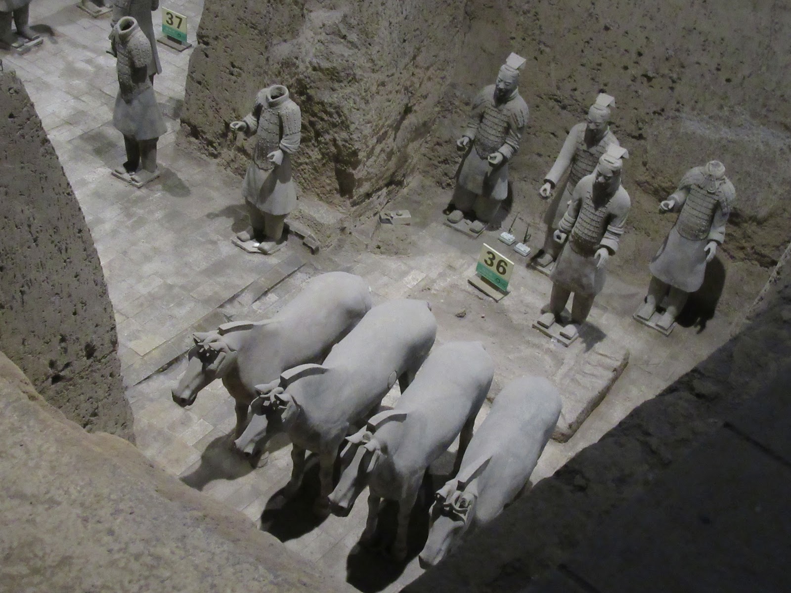
Terracotta Warriors with horses
Photo: Clare Golden
By 230 BC, the Qin’s military campaign and drive to unification was unstoppable. By 221 BC, the remaining kingdoms – Han, Zhao, Wei, Yan, Chu, and Qi – had each been conquered and assimilated. The entire territory of what was then China had been united.  Immediately after the unification of China in 221 BC, Ying Zheng proclaimed himself Qin Shi Huang.

The Origins of Ying Zheng
In 246 BC, King Zhuangxiang died, and Ying Zheng became King of the Qin at just 13 years of age.  He too appointed Lu Buwei as his chancellor but given the King’s youth and inexperience, the cunning ex-merchant effectively controlled the kingdom of Qin. When he was aged 22, Ying Zheng finally banished Lu Buwei and replaced him with another advisor, Li Si.
Before unification only aristocrats could hold rank and power, but the Qin created a system of ranks and grades that rewarded all men for success in battle. Success was measured by the number of decapitated heads of enemies taken; one head was rewarded with one rank, two heads with two ranks etc, the officers were given rank depending on the number of heads their subordinates removed.

Standardisation and Innovations
Together with the Great Wall, the road network, the Lingqu canal and the famed mausoleum, the building of the Emperor’s palaces was one of the largest construction projects in the Empire. After several relocations, the Qin capital was finally moved to Xianyang, about 12 miles north-west of present day Xi’an, in 350 BC by Duke Xiao.
To control the rich and powerful families of his conquered kingdoms, the Emperor ordered 120,000 influential families to relocate to Xianyang city. He also ordered the families to recreate the famous halls and palaces of their conquered kingdoms along the north bank of the Wei River. The buildings were linked to one another so that the First Emperor might walk among them and contemplate his many triumphs.

The Death of the Emperor
Between 220 and 210 BC, Qin Shi Huang made five inspection tours of his realm, and had seven inscribed stelae (stone tablets) erected on sacred mountains. The stelae inscription texts are valuable sources of information about Qin literature and ritual. During his third tour in 218 BC, the First Emperor survived an assassination attempt in Wuyang (in present day Guangdong Province). The First Emperor conducted his fifth tour in 210 BC, again to the east, but died on the return journey, aged just 49.
Qin Shi Huang was fearful of death and searched for an elixir that would make him immortal. At the same time, he commissioned the building of his mausoleum at the foot of Li Mountain, 35 kilometres from the modern city of Xi’an. He ordered the palace alchemists to make potions which contained mercury in the hope it would extend his life, little realising that mercury is poisonous.
Terracotta Warrior
Photo: Clare Golden
The Tomb Complex of the First Emperor of China
 In death, as in life, Qin Shi Huang had everything to continue his rule: a Terracotta Army to protect him; bronze chariots for travelling; terracotta acrobats for his entertainment; an arsenal storing stone armour, stables full of horse skeletons, and his concubines buried alive with him.
Those who accompanied the Emperor on his final inspection tour, particularly Zhao Gao and Li Si, concealed the news of his death and instead returned to Xianyang with the intention of naming a new emperor of their choosing. They had the Emperor’s corpse concealed in the imperial chariot, and to mask the putrid stench in the summer heat they loaded a cart with salted fish to accompany the chariot back to the capital.
The First Emperor had many concubines and fathered many sons and daughters. Fu Su, his eldest son and likely heir, had displeased the Emperor by criticising his father’s book burning and had been sent away to the northern border. However, the Emperor had given orders suggesting that Fu Su should become his successor.
Zhao Gao ignored these wishes and through political manipulation engineered the accession of Hu Hai, a younger son of the Emperor with whom he had become friendly. Fu Su was forced to commit suicide and Zhao Gao also contrived the death of General Meng Tian, known for his military abilities and the construction of the Great Wall. Following the suicide of the Second Emperor, Zhao Gao placed his own nominee, Ziying, on the throne.
The Qin Dynasty was short-lived. After Qin Shi Huang died it ended abruptly due to the influence of Zhao Gao and the weakness of the Second Emperor. Within five years of the First Emperor’s death, peasant rebels had stormed Xianyang and one of the leaders, Liu Bang, had taken the throne and established the Han Dynasty (206 BC – AD 220).
The Han Dynasty lasted for more than 400 years and rivalled the almost contemporary but smaller Roman Empire in the west. A census in AD 2 records almost 60 million people in the Chinese Empire.

The Qin and Han Legacies
Modern China retains many of the vestiges of both the Qin Empire and its longer-lived successor, the Han Dynasty. This is evident in the physical structures that remain but also in the beliefs and cultural practices of the Chinese people. Much of Chinese culture can be traced back to the Han Dynasty. It was an era of peace and prosperity that allowed China to expand to become a major world power.
The Han love of jade also continues. The Qin influence is probably best evidenced by the physical structures that remain, The Great Wall of China, the road network, the Lingqu Canal, and of course the First Emperor’s tomb are all prominent relic of the Qin’s extreme ambition and power.

This article is based on the book: China’s First Emperor and the Terracotta Warriors by

James CS Lin and Xiuzhen Li – Edited by Karen Miller (2018) which accompanies the exhibition at the World Museum, Liverpool which runs until 28th October 2018.


Friday, April 27, 2018

Corlea Iron Age Trackway

Detail of Corlea Trackway, County Longford, Ireland
Photo: Flickr

Ancient Origins website featured the Corlea Trackway in County Longford on 14th April 2018.  This important archaeological site warrants wider publicity because of its unique nature and the excellent visitor centre built on the site.
The Corlea Trackway, known in Irish as Bóthar Chorr Liath, is a timber trackway dated to the Iron Age. This ancient trackway is located near Keenagh, a village to the south of Longford, in County Longford. It was discovered during the 1980s, when it was exposed during the harvesting of peat. Today, the Corlea Trackway is on permanent display in a specially constructed exhibition centre built at the site of the discovery. 
This trackway is composed of oak planks resting on a foundation of birch rails. Based on tree ring dating (known also as dendrochronology) conducted at Queen’s University Belfast, it was determined that the trees used to build the trackway were felled either in late 148 BC or early 147 BC. 
Largest Wooden Trackway in Europe
Corlea is the largest wooden trackway or togher discovered in Europe, spanning about one kilometre of bogland and is about three and a half meters wide. It is estimated that three hundred large oak trees were felled to create the planks and about the same amount of birch was needed for the rails. This equates to about a thousand wagon-loads of construction material.
The first routes in Ireland were prehistoric trackways, some of which were later developed into roads suitable for wheeled vehicles. Trackways typically date to the early to middle Neolithic period, the Middle and Late Bronze Age, early Iron Age (c. 500-300 BC) and throughout the early medieval and late medieval periods.
 
Detail of preserved section of Corlea Trackway
Photo: Wikimedia
The Corlea Trackway is unique in Ireland due to its large width and smooth surface, suggesting that it was used for wheeled vehicles such as carts or, perhaps, even chariots. Two massive block-wheels, dating to about 400 BC, which were found in 1968 and 1969 in Doogarymore, Co. Roscommon, are the earliest direct evidence at present known for wheeled transport in Ireland.

Wooden Wheel, Doogarymore, County Roscommon
Further Trackways Discovered
Research carried cut by Dr. Barry Raftery of University College, Dublin, over the five-year period 1985 - 1989, in the Mountdillon complex of bogland, Co. Longford, has done much to increase our knowledge of this hitherto neglected aspect of our history. (Trackways Through Time by Barry Raftery - Headline Publishing). During this time some 57 tracks were excavated, some extensively, and more to a limited degree. Excavations up to 1991 in Corlea bog discovered 59 toghers in an area of around 125 hectares while further work increased the total to 108 with a further 76 revealed in the nearby Derryoghil bog.
Peatland once covered some 16% of the land surface of Ireland. Prior to modern drainage much of central Ireland consisted of soggy marshland interspersed with areas of dry land. This presented enormous problems for the ancient traveller whose existence involved moving about the land. The early inhabitants of Ireland lived on the uplands where they looked after their herds and cultivated the land, which would have been surrounded by large areas of wetland. 
 Theories of Use
It is unclear how the Corlea Trackway was used by the Iron Age people living in the locality. Some archaeologists, for instance, have argued that our ancestors used the trackway to cross the bog. Others, however, believe the trackway allowed people to travel into the bog, where rituals could be carried out.
The life of these ancient roadways would have been short in view of the extremely wet conditions in the continually growing bog. The trackways would quickly sink into the soft peat and become covered in vegetation. Projecting pegs would have marked the route through the bog after the walking surface had become obscured.
Corlea Visitor Centre
              Photo: Longford Tourism
Preservation
Peat bogs, provide an ideal environment for the preservation of organic remains, including wooden artefacts. The acidic conditions create an environment which is low in oxygen. This prevents the growth of microorganisms, which helps to preserve organic remains, such as wood, leather, and even the soft tissues of humans or animals. 
Hundreds of ancient bog bodies have been discovered in the boglands of Europe over the last few centuries, of which about 130 have been found in Ireland. Most of bog bodies date from the Iron Age. Experts believe that many of the Irish Iron Age bog bodies are the remains of former kings who were sacrificed.
Today, some 18 meters (60 ft) of the Corlea Trackway is on permanent display within the Visitor Centre. A boardwalk, which follows the course of the remaining trackway that is still buried under the bog, was constructed to allow visitors to have a sense of how the Corlea Trackway may have looked during the Iron Age. The Corlea Trackway ended on a small island from which a second trackway, also radiocarbon dated to 148 BC, connected to dry land on the far side of the bog. This second trackway was also around one kilometre long. 
Conclusion
The Corlea Trackway was built from trees felled either in late 148 BC or early 147 BC  giving us a precise date for its construction. It was a major building project for its time requiring a high level of both skill and social organisation. The trackway was preserved by the unique conditions which exist in our boglands. While we cannot say for sure why the Corlea Trackway was built all those years ago, we can marvel at such an achievement. The visitor centre housing the trackway provides a wealth of information on this and other bogland discoveries but do check the opening times if you are planning a visit.
For further information please see: