Monday, December 7, 2015

Carrowntemple - Early Christian Enclosure

Grave Slab 2 - Carrowntemple
My recent posts dealt with Boyle and Cloonshanville Abbeys so I thought I would continue the monastic theme by including the early Christian site at Carrowntemple, near the village of Gurteen, Co Sligo, in my blog. There is an excellent piece about this early church on the Lough Gara Lakes and Legends website.

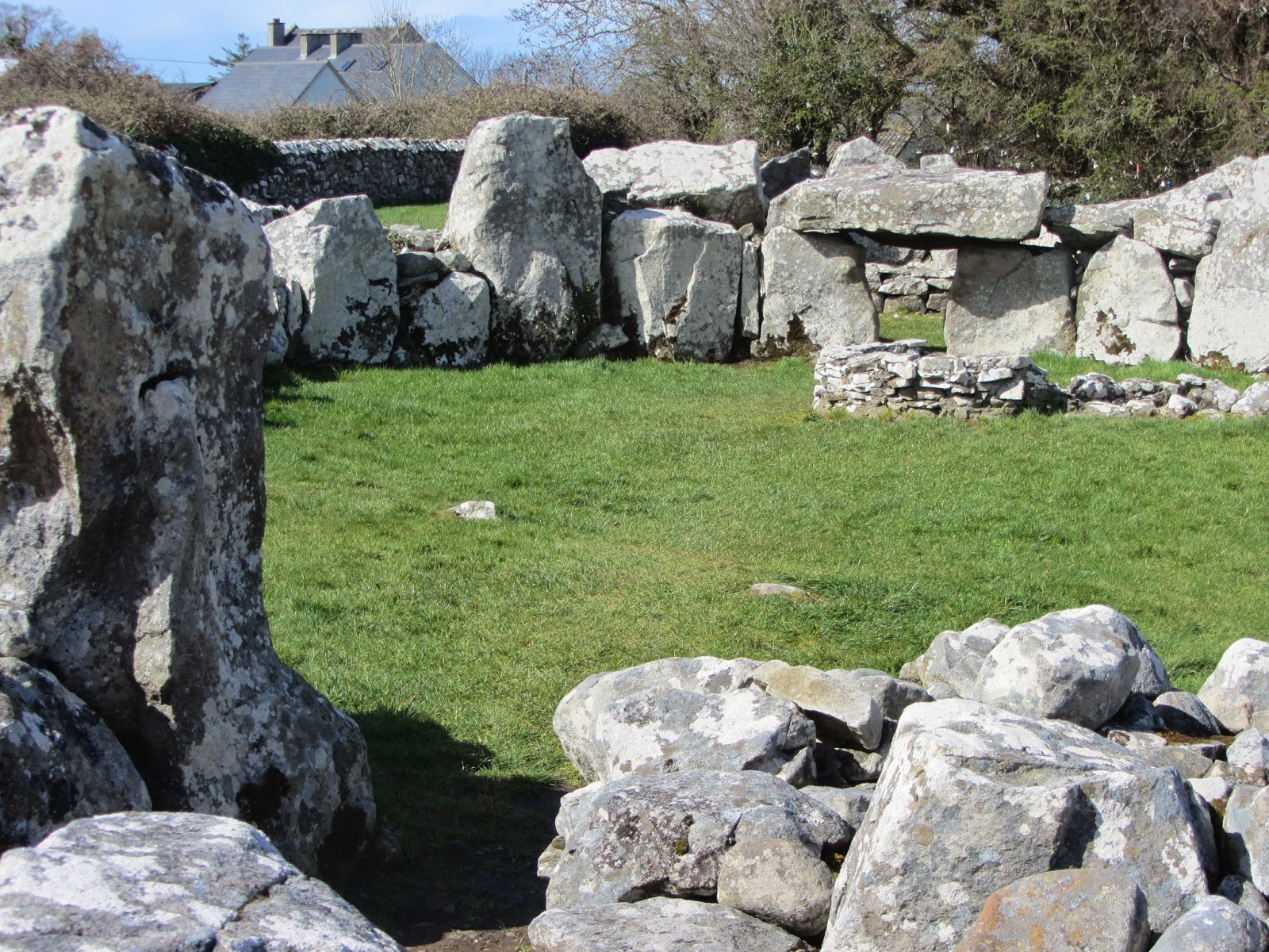
There were originally two enclosures around the Carrowntemple complex but both are now partly demolished. The area of the inner enclosure is 0.4 ha. (1 acre) while the outer enclosure has an area of 6 ha. (15 acres). At the centre of the inner enclosure are the remains of a plain medieval parish church measuring 9.40m by 6.40m still standing 3.10m high. This church is probably on the site of earlier wooden churches going back in time to the foundation of the monastery. The church had a single-light east window.

Grave Slab 3 - Carrowntemple
Souterrains or underground chambers to the west of the church ruins would have been used for storage and refuge in times of trouble.

Over the years fourteen stone grave slabs, dating from the early Christian period, were found mainly to the south and east of the church within the old graveyard. In 1984 five of these slabs were removed from the graveyard. These were recovered in 1986 and, later that year, the remaining exposed slabs on site were taken into care by Sligo County Council.

Grave Slab 5 - Carowntemple
Between 1990 and 1992 Cillian Rogers made replicas of the slabs for the Council and these are well worth a visit. The finance for this project was provided by the National Heritage Council. Two of the original slabs have been on display in the National Museum of Ireland.

Martin Timoney, archaeologist, states that the Carrowntemple grave slabs are surprising in two ways:

“Firstly, how so many superb slabs did not come to archaeological notice until 1973 is simply amazing. Secondly, some of the designs are outstanding, even unique, for many reasons.”

Moylough Belt-Shrine
He points out that two of the slabs (No’s. 2 and 3), bear art of the Early Christian period that is derived from the Celtic art of the preceding Pagan Iron Age. One of these is very close to a design in the book of Durrow and is datable to c. 650 AD. Several of the panels of the seventh century Moylough Belt-shrine, found only a few miles west of Carrowntemple, have this same mix of Pagan and Christian artwork. Some of the slabs are linked by their designs and so a 7th and 8thcentury date has been accepted for many of the slabs.

Grave Slab 6 - Carrowntemple
Half of a cylindrical plinth stone, thought to have been used to hold erect the double-sided No 10 slab was found. The designs are considered to be much more elaborate than those of any other Co Sligo grave slab of the period with the exception of those on Inishmurray. On slabs 3,4,5,6,8 and 11 it is the band and not the groove that forms the design.

The Carrowntemple grave slabs raise interesting questions about the transition between pagan Ireland and the arrival of Christianity. Edel Bhreathnach’s excellent book “Ireland in the Medieval World AD 400-1000” provides some valuable insights into this period.

The coming of Christianity to the island is traditionally linked to St. Patrick, who is said to have converted the Irish during the early fifth century. However, Palladius was sent by Pope Celestine a year earlier in AD431, to minister as bishop ‘to the Irish believing in Christ’. Scholars believe that the existence of Christian communities in Ireland was known to Rome at this time.

Patrick left an account of his mission in two important Latin documents, his Confessio, which was a defence of his mission against critics in Britain, and his Epistola, a letter condemning a British king, Coroticus, for attacking and enslaving some of his newly converted Christian flock.

Christianity in early medieval Ireland was administered by bishops, priests and abbots, some in orders, others who were lay people. All kinds of church buildings were constructed from simple post and wattle structures to larger stone churches and monumental enclosures.

The two prevalent burial types in Ireland from the late centuries BC and early centuries AD were cremations and inhumations, with the former more prevalent in the early period and inhumation becoming common into the first millennium AD.  Interestingly, cremation did not become obsolete, and instances of this practice have been dated to as late as the eight century.

For Christian and non-Christians alike, death, burial, and the subsequent treatment of the dead, were purely matters for the family. The Christian clergy were not involved at all and pagans and Christians were buried alongside one and other in family graves.

However, during the fifth and sixth centuries, burial practices for the nobility - clerics, kings and other aristocrats – began to change. This was due to what has been described as the cult of saints. Early Christians believed that by being buried near a holy grave they could hope to stand beside the saint on the day of the resurrection. The practice of burying people inside city walls developed, so that they could rest near the altars of urban churches.

Grave Slab 10 - Carrowntemple
Irish society of the early medieval period very gradually progressed from ancestral and familial rites to rites and cemeteries controlled by the church. Often these practices were not mutually exclusive. Some non-Christian funerary customs continued to be practised, including burial in cemeteries not obviously associated with a church.

It is not until at least the eight century, when the church exerted its influence more widely, that it is possible to classify with some certainty the difference between a Christian and non-Christian burial or cemetery.

The Christian rituals most prominent in St. Patrick’s Confessio and Epistola are the rites of baptism and confirmation which were rites of passage and initiation. Christian baptism, conferred a new identity on Patrick’s followers that, in the fifth century, would have probably set them apart from their own society, thereby, creating a community within a community.

Scholars believe that wells were used instead of baptisteries in Ireland, which may explain the proliferation of holy wells throughout the country. Holy wells are thought to have been sacred places in pre-Christian times and may have continued to be associated with non-Christian rituals.
 St Attracta's Holy Well - Clogher


Carrowntemple, with its intricately carved Early Christian grave slaps derived from the Celtic art of the preceding Pagan Iron Age, offers a glimpse of the intersection of these two important periods in the history of Ireland.


For further information please see:
Bhreathnach, Edel, ‘Ireland in the Medieval World AD 400-1000’ (Four Courts Press 2014)
http://www.loughgaralakesandlegends.ie/carrowntemple-grave-slabs

Tuesday, October 20, 2015

Cloonshanville Abbey

Cloonshanville Stone Cross
Photograph courtesy Flickr 
In 1385, the MacDermots Roe are said to have established the Dominican Priory of the Holy Cross at Cloonshanville, near modern day Frenchpark in County Roscommon. However, it has been argued that it was, in fact, MacDermot Gall that founded this abbey, since it was in their territory and far from any MacDermot Roe land.

MacDermot Gall was chief of Airteach, which was an area west of the Breedogue River and bordered on the northside by the River Lung and Lough Gara. MacDermot Roe was chief of Tir-Tuathail, lying to the west of Lough Allen. The Abbey occupies the site of an early monastery founded by St Conmitius who was bishop there in the time of St Patrick.

The ivy covered bell-tower still stands and some ruined walls may be seen. The tower has a simple pointed vault with holes for two bell-ropes. Three of the four corbels in the vault are decorated with small floral motifs and simple interlaced crosses. Much of the detail of the outer wall of the tower is obscured by the ivy. An interesting feature of this abbey is the Piscina which is a shallow stone used for washing the communion vessels.

The Dominicans first arrived in Ireland in the year 1224, three years after the death of St Dominic and the arrival of the friars in England. Two foundations were made in Ireland that first year; one in Drogheda and one in Dublin. The Dominican friars initially made foundations in those regions of Ireland under Anglo-Norman control, but they soon established themselves in the Gaelic parts of the island also. Twenty four Dominican communities were founded in Ireland in the thirteenth century.

Piscina - Cloonshanville
Photograph courtesy Flickr 
Monasteries such as Cloonshanville, Boyle Abbey and Trinity Island are a significant feature of settlement in County Roscommon and would have played an important role in the development of a communications network. Two major roads - the Slighe Assail and the Slighe Mhor- linked Connacht to the east-coast ports and to English and continental markets.

In the official records of the Anglo-Norman administration, control of roadways is seen as vital to the safety of local communities and the conduct of the king's business. The Slighe Assail was traditionally the main road from Meath to Connacht and can clearly be seen to be focused on Cruachain or Rathcroghan as it is more commonly known today. In addition to the crucial focal point of Cruachain, the Slighe Assail passes close to a number of early Christian establishments.

In both Longford and Roscommon, minor roads radiate from the Slighe Assail. In Roscommon a number of these converge on important early Christian and later ecclesiastical centres: Mocmoyne (just east of Boyle), Cloonshanville, Tibohine and Elphin, which was the diocesan centre for east Connacht for the greater part of the medieval period.

The River Boyle, the principal tributary in the upper reaches of the Shannon, flows out of Lough Gara and through Lough Key, a shallow lake with many substantial wooded islands. Some of these islands have important archaeological remains: the monastery of Trinity Island, for example, and the remains of the Mac Diarmata stronghold at Carraig Mac Diarmata.

The Shannon River with the two major routeways - the Slighe Assail and the Slighe Mhor - provided relatively easy access to the outside world throughout the medieval period.

In 1977 the National Parks and Monuments Branch of the Office of Public Works carried out a limited excavation at the site of a stone cross close to Cloonshanville Abbey. No archaeological material or any evidence of occupation was found in the excavated area.

An elderly Frenchpark resident recalled that the old people told stories of coffins being left at the cross to be taken into the Abbey later by the monks. It was also said that at times you can hear the sound of church bells coming from the nearby boglands where monks perished while trying to escape to Boyle.

The cross is made from rough sandstone. It has an overall length of 3.90m, only 30cm of which was not visible above the ground prior to excavation. There is a large crudely made boss on each face of the cross at the intersection of the shaft and arms. No further attempt appeared to have been made to decorate the cross. The arms extend 14cm to 16cm out from the shaft. Archaeologists believe that the Cloonshanville cross is medieval in date and probably erected in the twelfth century.


Theobald Dillon got possession of Cloonshanville after the dissolution of the Monasteries. The Dillon’s settled in Ireland after the Norman Conquest in 1169 and were a landlord family from the 13th century in a part of County Westmeath called 'Dillon's Country'. His great-grandson, the seventh Viscount, was a supporter of the Catholic King James II of England and was outlawed after the Glorious Revolution or the Revolution of 1688. He founded 'Dillon's Regiment' of the Irish Brigade in the French Army, which was supported by the Wild Geese and achieved success at Fontenoy in 1745.

Tuesday, October 6, 2015

Boyle Abbey

Boyle Abbey
I was pleased to see that Archaeology Ireland’s Heritage Guide No. 70 (September 2015) was dedicated to Boyle Abbey.

In 1148 twelve monks and their abbot, Maurice O’Duffy, set out from Mellifont, Co. Louth, with the intention of establishing a Cistercian house in Connacht and eventually settled on the west bank of the Boyle River in 1161. Mellifont had been founded in 1142 by monks from Clairvaux in France. Boyle Abbey Church was finally consecrated in 1220.

It is of Romanesque and Gothic design and despite being plundered on a number of occasions, remains one of the finest examples of Medieval art.

The monastery was laid out according to the usual Cistercian plan, around a central cloister garth. To the immediate north of this lies the church, with the chapter house and abbot’s parlour on the east side, the kitchen and refectory on the south and the dormitory on the north side of a roughly rectangular cloister area.
Remains of Cloister and Garth

Much of the detailing of the nave and particularly the cylindrical piers of the south arcade has strong echoes of the West of England. The decorated corbels and capitals belonging to them were probably carved by local masons, some of them members of the so-called ‘School of the West’, creating some of the most inventive architectural sculpture of the early thirteenth century in the West of Ireland.

The Abbey has been considerably altered over the years and at one time served as a military barracks. After the dissolution of monasteries in 1541, the Abbey survived for some years under the protection of Ruaidhri Mac Diarmada, King of Magh Luirg who was granted the monastic lands. However, by 1592 the abbey was being used as a military barracks by Richard Bingham, Governor of Connacht. In 1645 the monastery came under attack by Irish forces during the Cromwellian wars.

The gatehouse is thought to have been built during the 17th Century military occupation but may contain parts of the original entrance to the monastery. It leads into the cloister garth which still survives but with a cobbled surface which was laid down during the military occupation. At this time the cloister arcade was destroyed and new walls constructed to the south and west.

The Nave - Boyle Abbey
The abbey church is a long cross-shaped rectangular building. The east end of the building is thought to have been built shortly after the abbey was founded in 1161. Contrasting styles of architecture can be seen in the arches and pillars of the nave. Some of the pillars on the south side of the nave are cylindrical and the arches are Romanesque in style. The pillars opposite them on the north side are square with pointed arches representing the move towards a Gothic style.

Some similarities between Boyle Abbey and Christ Church Cathedral in Dublin have been noted and it is possible that some of the same craftsmen may have worked on both buildings. A number of the arch columns and corbels are highly decorated with different floral motifs and other decorations including: two male figures standing between trees, two dogs fighting and a pair of cockerels.
A number of medieval graveslabs have been found on this site. These include a thirteenth-century abbot’s gravestone which shows an arm holding a crozier while others bear the names Ua Mailchanig and Matheus.
Gravestone
The Cistercians remained at Boyle Abbey until the 16th century. Although Henry VIII introduced legislation in the Irish Parliament in 1537 for the dissolution of the country’s monasteries, his authority did not extend throughout Ireland and so the majority of houses continued as before.
However, Boyle became caught up in a family dispute among the MacDermotts and in 1555 the abbey was burnt with further assaults in the following years. In 1569 the abbey was granted by the English crown to Patrick Cusack of Gerrardstown, County Meath.

Boyle Abbey was the official family burial place of the MacDermots from the end of the twelfth Century until the latter part of the sixteenth.

Major conservation work was carried out on the Abbey during the period 2006 – 2012. This work followed an archaeological excavation to establish the original line of the north aisle wall which no longer exists. A new exterior wall and roof, made of reinforced glass, was erected reflecting the outline of the original building. Archaeological excavations produced evidence of medieval occupation including pottery, coins, pins and graveslabs together with numerous burials.


For further information please see Archaeology Ireland Heritage Guide No. 70 (September 2015)

Monday, July 20, 2015

Moygara Castle

Moygara Castle, Co. Sligo
Moygara Castle dates mainly from the late 16th or early 17th century. Lough Gara and the nearby castle are named after the O’Gara family who ruled the area around the lake since 1285 AD. The O’Garas built three castles in the area, the main one was at Moygara built on the NW corner of Lough Gara.

It is a square-walled structure with a tower at each corner. The main gate and remains of the portcullis are located on the west wall. The four corner-towers are similar in plan and layout but the SW tower stands to three storeys high whereas the other three are only two storeys. All the door and window frames and lintels were made of wood although none of these survive today. The oldest part of the castle is a ruined rectangular structure which may have been an earlier tower house. The walls are recessed 11 feet from the face of the towers and stand 15 ft. high and 4 ft. thick and are loop-holed for the use of firearms.

The original territories of the O’Garas consisted of part of the Barony of Leyney in Co. Sligo. They were driven out of their territory by the Anglo-Norman families of the Nangles (later Costelloe) and the Jordans. Later, they moved to what was known as the Sliabh Luagh district of Co. Mayo. This area included the parishes of Kilkelly, Kilmovee, Kilbea, Kilcolman and Castlemore. The O’Garas finally settled in Coolavin.

In May 1169, Anglo-Norman mercenaries landed in Ireland at the request of Diarmait Mac Murchada (Dermot MacMurragh), the overthrown King of Leinster, who had sought their help in regaining his kingdom. This military intercession had the backing of King Henry II of England. Pope Adrian IV - the only English Pope - had authorized Henry to conquer Ireland as a means of bringing the Irish church into line. In the summer of 1170, there were two further Anglo-Norman landings, led by Richard 'Strongbow' de Clare.

In October 1171, King Henry landed a large army in Ireland to establish control over both the Anglo-Normans and the Irish. The Norman lords handed their conquered territory to Henry. Many Irish kings also surrendered to him, in the hope that he would curb Norman expansion.

The largely successful nature of the invasion has been attributed to a number of factors. These include the Anglo-Normans' alleged military superiority and programme of castle-building; the lack of a unified opposition from the Irish; and the Church's support for Henry's intervention.

An early drawing of the castle (1786)
In the 16th Century, Moygara Castle was the home of Fergal O’Gara. He is famous as the patron of Fr. O’Cleary and his colleagues who compiled “The Annals of the Four Masters”. He died sometime around 1660 and is said to have had at least three sons, John, Cian, Charles and, possibly, a fourth named Bernard. John O’Gara’s son, Fergal’s grandson, Oliver, held the rank of Lieutenant in Viscount Montgomery’s Regiment of Foot in 1686.

Oliver had hoped for the restoration of his lands under James II. He raised a regiment known as “O’Gara’s Infantry” and served with distinction at the Battle of Aughrim. Following the defeat of the Jacobite cause and the Treaty of Limerick, Oliver left for the continent. He rose to the rank of Lieutenant Colonel in the French army and was appointed Governor of Montega in Spain in 1705. He died there some years later. Another grandson of Fergal’s, Charles, settled in Co. Mayo. He had at least two sons, Bernard and Michael, both of whom became Archbishops of Tuam, Co. Galway.

Moygara Castle - Corner Tower
In 1538, Manus O’Donnell, having captured the Castle of Sligo and savaged Moylurg, took the Castle of Moygara. As his army was approaching the walls a ball fired from inside the castle killed his son. In 1581, the Castle was the scene of an even greater tragedy. A body of mercenary Scots in the service and pay of Captain Malby, Governor of Connaught, burned the building and Diarmuid Og, son of Cian O’Gara, was put to death.

The Anglo-Norman invasion was a defining moment in the history of Ireland, marking the beginning of more than 700 years of direct English and, later, British involvement in Ireland. Today, the ruins of Moygara Castle stand as testament to a turbulent time in Irish history.

http://www.moygaracastle.com/


Saturday, May 2, 2015

Silence in Court - Creevykeel Court Tomb


Creevykeel Court Tomb - County Sligo
Hidden behind a tall hedge on the busy Sligo to Bundoran road lies the Creevykeel Court Tomb. There, the casual visitor will find what looks like a low elongated pile of stones of varying sizes some of which have been deliberately positioned. However, there is much more to this ancient site than meets the eye.
More than 6,000 years ago, the Neolithic or New Stone Age peoples of Western Europe began to build stone monuments over their dead as tombs and ceremonial places. This was the beginning of what has become known as the megalithic tradition of the Neolithic period.
Creevykeel Court Tomb is amongst the finest examples of its type in Ireland. It dates from the Neolithic Period, 4000-2500 BC and was excavated in 1935 and then restored. The monument is located on the foothills of Tievebaun Mountain close to the sea near Mullaghmore in County Sligo. The old name for Creevykeel is Caiseal a' Bhaoisgin, the Fort of Bhaoisgin, Bhaoisgin being the well near the cairn.
The cairn measures 55 x 25 meters, with the wide edge to the east and tapers away to a tail at the west end. The actual court itself, which is enclosed by the cairn, is oval in shape measuring 15 x 9 meters. It is lined with large boulders that rest on the surface rather than sunk into the ground. The main body of the cairn was originally surrounded by a stone revetment to hold the mound together.
A narrow entrance passage, lined with large boulders and approximately 4.5 m in length, leads from the east end to the court. There is a two-chambered gallery to the north west of the court. Three smaller chambers can be seen at the western end of the monument, two on the north side and one on the south side. These are quite different to the main chamber, and are considered by some archaeologists to be small passage graves.
Court with Christian Feature top right
Large areas of the court were paved with small flat slabs while in places, cobble stones and sea sand from the nearby shore was also found. Archaeologists found evidence of large fires within this enclosed area as well as fragments of cremated bone and charcoal. The standing stones (orthostats) around the court are quite massive chunks of local sandstone. They get larger approaching the opening at the rear of the court, which gives access to an inner chamber, now roofless but which was originally covered with massive corbels, making an artificial cave.
It is unclear whether the eastern end was originally the higher as well as the broader, as is generally the case with these monuments. However, the excavation showed that the builders had used the natural slope of the ground to obtain the effect of height at this end.
Court-tombs date from the Neolithic Period and are found mainly in the northern half of the country. Most of these sites are to be found north of a line extending from Dundalk to Galway. Their most distinctive feature is the ceremonial court which is set in front of a gallery or galleries divided into two or more burial chambers.
The court usually occupies one end of a long cairn but sometimes there are courts and chambers at both ends of the cairn. In other examples, as in the case of Creevykeel, the court is completely enclosed within the cairn and is of circular or oval shape, access being gained through a short narrow passage leading to the front of the cairn.
These megalithic monuments usually had two functions: the chamber to serve as a tomb, and the courtyard to accommodate some form of ritual. Objects were often buried with the deceased, as the first Neolithic farmers believed in life after death.
Excavations at Creevykeel uncovered four cremation burials, decorated and undecorated Neolithic pottery, flint arrow heads, polished stone axes, a flint knife, stone bead, four blue glass beads, a small bronze broach and stud, part of a red deer antler handle, part of a comb and other artefacts, including a clay ball.
Over 133 stone axes alone have been discovered along the shores of Lough Gara. Stone axes are normally ascribed to both the Mesolithic and the Neolithic periods. Polished stone axes, however, seem to appear first in the Neolithic while ground axes can belong to the Mesolithic or Middle Stone Age. These tools were used for cutting, shaping and dressing wood. A small polished stone axe was also found during excavation of the Drumanone Portal Tomb close to Lough Gara.
Kiln from Early Christian Period
Inside the court area archaeologists discovered a kiln dating from the Christian Period together with evidence of iron-smelting. Iron Age and early Christian metalworkers seem to have liked working in ancient sites including crannogs. Such ancient sites may, perhaps, have held magical properties in relation to metalwork.
Archaeologists excavating a crannog at Lough Gara in the townland of Sroove found a small bowl-shaped depression that may represent the shape of a small bowl-furnace for iron-smelting. Nearby, was found remains of slag, some pieces of which had the red clay remains of the furnace attached to them. 
Creevykeel Court Tomb remains one of the best examples of its type in Ireland and is well worth a visit if you happen to be in that part of North Sligo which has a rich megalithic tradition.

Monday, April 20, 2015

Lough Gara and Ireland's Mesolithic Period

Lough Gara Lake
Archaeologists can tell us a great deal about the Irish Neolithic period or New Stone Age and subsequent times such as the Bronze and Iron Ages as well as medieval times. There is evidence of the past all around us in the form of cairns, portal tombs, boulder burials, standing stones, crannogs and, of course, the ubiquitous ring forts. Much less, however, is known about the Mesolithic Period or Middle Stone Age. What was life like for those early settlers living around Lough Gara and similar lakes in the West of Ireland?

It has been suggested that these early people moved from the sea to the lakes and inland in a seasonal cycle. The winters were spent hunting wild pig in the forests, while in the spring people moved to the sea to collect oysters. At the beginning of summer they followed the fish like salmon and eel upriver.

The land which now comprises the island of Ireland came about following the collision of two continents about 430 million years ago. The formation of Ireland in its present shape only occurred 12,000 – 10,000 years ago. There is some evidence that animals such as bear, woolly mammoth, red deer, giant Irish deer, horse, and wolf roamed Ireland around 40,000 to 20,000 years ago. The remains of mammoths have been discovered near Crumlin, Co. Antrim that date from over 40,000 years ago. The next 7,000 years (18,000 -11,000 BC) was probably the height of the glacial period (Mallory, 2013).

By 12,000 BC the climate in Ireland had become increasingly warmer and the ice sheets were melting. These conditions allowed the gradual spread of trees and other plants northwards into Britain and Ireland. Because of the lack of large areas of grasslands, mammals and other animals became extinct. By 8000 BC Ireland was separated from Britain. This helps to explain why Ireland has a poorer range of native plants and animals and appears to have been settled by people much later.

Mallory points out that there is no evidence that people settled in Ireland earlier than 10,000 years ago. The Mesolithic or Middle Stone Age lasted for about 4,000 years and is divided into two periods: Earlier Mesolithic c 8,000 – 6,500 BC and Later Mesolithic 6,500 – 4,000 BC.

Flint Implements
More evidence of life during the Mesolithic Period is gradually coming to light with around twenty important sites identified around Ireland.  Early Mesolithic communities are characterised by the use of flint cores, flakes, and ground and polished axes. The Later Mesolithic Period saw a shift to the use of larger stone implements and the continued use of stone axes.

Mount Sandel, near Coleraine, Co. Derry, is the oldest Mesolithic site in Ireland and dates from about 8000 BC. Archaeologists discovered traces of a series of huts that had been re-built from one occupation to the next. These early houses had been built using bent rods or poles and measured six metres in diameter with a hearth located in the centre.
Building a Replica Mesolithic Hut - Mount Sandel


Recently, archaeologists discovered the remains of two individuals in Killuragh Cave, Co. Limerick. Bones from this site have been dated to c 7,200 – 6,500 BC. At Castleconnell, Co. Limerick, the cremated remains of a complete adult were found, accompanied by a polished stone axe and two microliths or small flint blades. The grave appeared to have been marked by an upright post. This burial was dated to c 7,550 – 7,300 BC. 

The survey of Lough Gara by Christina Fredengren and a radiocarbon-dating programme, together with the artefacts, have shown that this lake was heavily used during the Mesolithic Period.  One of the posts found in this lake produced a radiocarbon date of 4230–3970 BC, indicating activity in the latest phases of the Mesolithic. A piece of brushwood from the same area was dated to the early Mesolithic, showing that there was human activity on the lake around 7330-7050 BC (Fredengren, 2002).

Where did the first Irish settlers come from? Scholars believe that the most likely ‘homelands’ of the earliest human colonists in Ireland are Scotland, Isle of Man and Wales.

Lough Gara
Most Mesolithic artefacts have been found in or near water, just as at Lough Gara. Mesolithic material has been recovered from other nearby lakes such as: Lough Allen, Co. Leitrim, and Urlaur, Co. Mayo. These two lakes are connected to Lough Gara via the river system.

The Lough Gara collection of stone axes is the largest Mesolithic assemblage in the West of Ireland. It is likely that the waters, and especially the running waters of the river, were seen as places where depositions of suitable objects could be made.

Killian Driscoll (2014) points out that evidence for the Mesolithic Period in the West of Ireland has gone largely unrecognised. In areas such as Lough Gara and Lough Allan, the extent of the evidence has been overlooked. Where lakes have been drained, much evidence can be found, but this creates a bias against areas away from the shores as well as from lake where no drainage has taken place.

Christina Fredengren (2002) Crannogs: A study of people's interaction with lakes, with particular reference to Lough Gara in the north-west of Ireland
J.P.Mallory (2013) The Origins of the Irish
Driscoll, K., Menuge, J., and O'Keeffe, E. (2014). New materials, traditional practices: a Mesolithic silicified dolomite toolkit from Lough Allen, Ireland. Proceedings of the Royal Irish Academy, Vol. 114C pp. 1-34.

Friday, March 6, 2015

Lough Gara - A Glimpse into the Past

Stone Implements - Irish Stone Axe Project
Recently, I came across a list of artefacts found on the shore and in the vicinity of Lough Gara, on the border between County Sligo and County Roscommon. It makes impressive reading and highlights the archaeological importance of the lake which is renowned for its large number of crannogs. People have lived on or around this lake off and on for several thousand years leaving behind evidence of their presence in the form of stone axes, arrowheads, swords, spearheads and such like remnants.

The archaeological evidence suggests that crannogs, or at least platforms, may have been built in this lake in the Late Mesolithic around 4,000 BC. The practice of building on the shallow shores increased during the Late Bronze Age, 1200–800 BC, and again in the Early Medieval period around 600 AD. Some crannogs were also used as late as the 17th century. Estimates of the number of crannogs on Lough Gara range from 145 to 369. According to Christina Fredengren (2002), the Swedish archaeologist who carried out an extensive survey of the lake, the highest number of crannogs that can be claimed for Lough Gara is 190.

Lough Gara is not a particularly accessible lake for the casual visitor and the crannogs can be difficult to find. It is in the nature of wetland archaeology that such sites do not have much of a visible presence. In a sense, the lake’s past only comes alive when we consider the vast number of ancient tools, weapons and other objects discovered here over the years.

The Early Mesolithic period in Ireland runs from 8000 to 5500 BC and the Later Mesolithic from 5500 to 4000 BC. Radiocarbon dating of samples of wood show that there was human activity on Inch Island around 7330-7050 BC. The Lough Gara collection of Mesolithic artefacts is regarded as the largest in the West of Ireland.

Artefacts recovered from Lough Gara include:
Bann flakes 1053, Stone axes 133, saddle querns 3, rotary quern stones 6, stone discs 49, chertflakes 599, chert scrapers 14, chert arrowheads 9, flint flakes 7, hammer stones 22, bone pins 5, bone needles 2, human skulls 6, bone points 11, flint arrowheads 9, bronze rings 8, bronze pins 10, bronze sunflower pins 3, bronze spearheads 3, bronze daggers 4, iron spears 7, iron axe heads 19, bronze trumpet end 1, bronze swords 3, bronze axe head flanged 4, iron swords 6, blue glass bracelet 1 and copper coins 15.

5,000 year old axe with a wooden handle from Denmark
Over 133 stone axes alone have been discovered along the shores of Lough Gara with the largest concentration found along the Boyle River. Another large concentration of ten axes come from Inch Island in the middle of the lake. A small number have also been retrieved from other townlands such as Falleens, Tawnymucklagh, Ross and Derrymore Island.

Stone axes are normally ascribed to both the Mesolithic and the Neolithic periods. Polished stone axes, however, seem to appear first in the Neolithic while ground axes can belong to the Mesolithic. These tools were used for cutting, shaping and dressing wood. Perhaps, one of those axes was used to cut timbers for the nearby 3,000 year old togher or trackway in the townland of Creggan? 

It is likely that the lake waters, and especially the running waters of the rivers, were seen as places where depositions or offerings of suitable objects could be made. It has been suggested that the lake could have been a gathering-place for small groups during the late Mesolithic period.

Archaeologists’ use the term ‘lithic’ to refer to flaked stone tools such as arrowheads, scrapers, ground and polished stone axes and such like items. Killian Driscoll (2006) carried out a reappraisal of the lithics from Lough Gara excluding finds from excavations. He claims that the number of artefacts found in and around this lake has been underestimated. For example, the actual number of lithics recorded for the townlands of Tawnymucklagh and Lomcloon alone should be in the region of 928 - over twice the original estimate.

The discovery of quern stones from Lough Gara shows that these early inhabitants of the area around the lake were grinding corn to make bread and porridge. The presence of a bronze trumpet end points to the playing of music at gatherings and celebrations. Pins and broaches were used to fasten or adorn garments.

The Drumanone portal tomb was excavated by archaeologists in 1954 and was found to contain a considerable amount of cremated bone, indicating that the tomb was used to bury several individuals. A small polished stone axe was also found which archaeologists believe came from the Tievebulliagh Axe Factory in Co. Antrim. Other finds from this site include two flint flakes and a chert core scraper.

An Amber Necklace from Lough Gara dated to c 800-700 BC
Excavation of Rathtinaun crannog produced a hoard of various items, including:  a necklace of amber beads, rings of bronze, of pure tin and three of lead with gold-foil cover, a pair of tweezers, bronze pin and six boar tusks.

Many of the items found during the more recent excavation of the Sroove crannog were connected with personal appearance - a comb fragment, bone pins, iron pins and lignite bracelets. The discovery of a sewing needle suggests that people may have worked with textiles at this site.


The large and diverse number of artefacts from Lough Gara help to paint a picture of a people going about their everyday lives striving to survive with meagre resources. They speak to us through the items they left behind giving us a tantalising glimpse of life in the area long ago.

Christina Fredengren (2002) Crannogs: A study of people's interaction with lakes, with particular reference to Lough Gara in the north-west of Ireland
Killian Driscoll (2006) The early prehistory in the west of Ireland: Investigations into the Social archaeology of the Mesolithic, west of the Shannon, Ireland

Saturday, January 31, 2015

St. Attracta's Holy Well


St Attracta's Holy Well
Clogher, County Sligo
         Some years ago, I wrote a short piece on my blog about St. Attracta and made reference to the Holy Well at Clogher, near Monasteraden, Co. Sligo, which bears her name. In July 2013 part of the wall of this well was demolished following an accident in which a young local man tragically lost his life. I am pleased to see that this important site has now been restored under the supervision of archaeologist, Martin Timoney.

St. Attracta was born in the 5th Century and was the daughter of a noble family. She founded a convent and hospice for travellers, where the seven roads met at Killaraght near Lough Gara that still existed as late as 1539. She also established churches and convents in Galway and Sligo. St Attracta was a contemporary of St. Patrick from whom she received the veil. A native of the County Sligo, she resolved to devote herself to God but was opposed by her parents. She fled to South Connacht and made her first foundation at Drumconnell, near Boyle, County Roscommon.

An article by Martin Timoney in Echoes of Ballaghaderreen 2014 provides some interesting information about this local landmark. He describes in some detail the crucifixion plaque set into the back wall:

‘This has the Crucified Christ with long hair and a pointed beard; he wears a rather rigid loin-cloth. His legs are proportionately far too thin. Either side are the Emblems of the Passion: a flail, hammer, pincers and bunches of reeds, a ladder, the pillar with a rope around it and a cock on top and a rope-like feature. There is an INRI above the cross which has a three-stepped base’.

Crucifixion Plaque
To the right of the crucifixion plaque there is a stone with an inscription. This has now been confirmed as I.H.S 1662, II, I:G. It is thought that the II may refer to the second year of reign of Charles II; The Restoration was in 1660. The initials I:G may stand for Iriel O’Gara of Moygara.

On the back wall there are eight large rounded stones. A drawing from c 1880, however, shows a total of twelve stones in position on top of the wall. Similar stones have been found at many Irish holy wells and are sometimes referred to as Praying Stones and Cursing Stones. Turning the stones clockwise was for good while turning them anti-clockwise was to inflict a curse.

Timoney’s ongoing research into Connacht crucifixion plaques records the earliest example as 1625 (Turlough) with the latest being about 1825. The nearest known crucifixion plaque to Clogher is at Tibohine with another such plaque at Cloonshanville, Frenchpark.

Finally, Martin Timoney reports that a die-stamped button was found in the back wall during the recent restoration work. The wording reads: “P&S Firmin 153 Strand”. He states that the Firmin Company was established in 1667 in London at Three Kings’ Court by Thomas Firming. They were at 153 Strand by 1796 but were no longer at this address after 1894. Therefore, the button was most likely manufactured sometime between 1796 and 1894 but it is not possible to say when it was placed at the well as an offering.


It would be interesting to know how the button got from the Strand in London to Clogher but then I expect that is another story.