 |
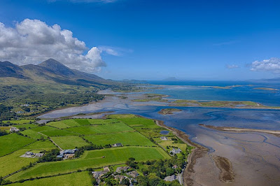
View of Clew Bay by Mariusz Z - flickr.com, CC BY-SA 2.0, https://commons.wikimedia.org/w/index.php?curid=89626431
My first glimpse of Clew Bay and
its many islands was in the early sixties while descending from Croagh Patrick
after climbing the mountain in the dark. A newspaper article reminded me of
that occasion. The Irish Independent recently reported the discovery of a
sunken prehistoric fort on an island in Clew Bay off the north Mayo coast. The
fort may be as significant as Inis Mór’s Dún Aengus.
Late Bronze Age Fort
Archaeologist, Michael Gibbons, told
the Irish Independent that surveys suggest that Collanmore island is
effectively a fort dating from the late Bronze Age (1100-900 BC). Several large
ramparts were uncovered cutting across the strip of land linking the island to
the shoreline. The ramparts are faced with large limestone blocks and extended
for 200 to 300 metres.
The size
and scale of the ramparts suggest that the island was of major strategic
importance at the time. Late Bronze Age hillforts are the largest monuments
built in Ireland and can measure up to 320 acres in area, with kilometres of
defensive ramparts.
Michael Gibbons told the Independent:
“They were built by warlord
dominated societies and we have very good evidence they were in active use
during periods of warfare between various tribes.”
Grace O’Malley or Granuaile
 |
Statue of Grainne Mhaol Ni Mhaille (Grace O'Malley, 1530-1603), the Irish Pirate, located at Westport House, Co. Mayo, Ireland. (Suzanne Mischyshyn/CC BY SA 2.0) |
Clew Bay was the stronghold
of the O'Malley clan during the Middle Ages – the most famous member of
whom is Grace O'Malley or Granuaile, the Pirate
Queen. Granuaile controlled a fleet of ships and possessed several castles,
including those on Clare Island and Achill, and at Rockfleet near Newport.
According to legend, Clew
Bay has 365 islands - an island for every day of the year. Ringforts are
Ireland’s most common field monument, with about 45,000 recorded examples. They
are circular areas, measuring c.24-60m in diameter, usually enclosed with one
or more earthen banks, often topped with a timber palisade.
Ringforts
While the term ‘ringfort’
dominates, other terms are also used such as rath, lios, caiseal and dun. Rath
and lios are normally used to describe monuments with earthen banks while
caiseal (cashel) and dun are more generally used in relation to sites with stone-built
enclosures. Stone forts or cashels are the equivalent of earthen banked ring
forts but are much less common. Dating of ring forts is difficult but most of
those that survive are thought to have been built well after the first century
with many built or used right into the medieval period (800 – 1500 AD).
The Bronze Age
The Bronze Age in Ireland was a
period of high population density and human activity sustained for a much
longer interval than any other time before or since. It is estimated that the
Irish Bronze Age sustained a population in the region of 2 m until 800 BC.
Prehistoric enclosures echo the
overall pattern of evolving population trends, occurring during times of higher
population. The basic causes of population change are tied to social,
political, and economic systems. They can be expressed through factors such as
famine, economic instability, political unrest, and changes to marriage
patterns that lowered fertility rates within kinship networks.
Ireland’s Ancient Routeways
By the end of the Bronze Age a
modern pattern of routeways crossing the midlands, joining west and east, and
east and north, can be observed. Ireland’s modern-day network of towns and
roads echoes ancient networks of routeways that connected significant points in
a landscape. Towns were eventually established in the places where this
internal network intersected with maritime connections with the world beyond
Ireland’s shores.
Climate Change
Archaeologists tell us that during
the eighth century BC, there is evidence of abrupt climate change. Across
northwest Europe, wetter oceanic weather became more prevalent, leading to a
dramatic rise in groundwater. The evidence suggests
800–780 BC was a period of environmental decline. Society’s capacity for
resilience was weakened by larger-scale social and economic changes in Europe.
This resulted in the most dramatic collapse in Ireland’s population until the
potato famine of the 1840s.
The population of Ireland
recovered to quite high levels during the Early Iron Age with levels of
activity around 400 BC like those sustained in Ireland throughout the Bronze
Age. Environmental disaster strike hardest at the sections of society most
exposed – the sick, very young, and very old. Likewise, political unrest and
war can have devastating results for entire age-cohorts of young men in
particular.
Summary
Archaeologists are excited to discover that one of the many
islands in Clew Bay, County Mayo, is a sunken prehistoric fort which dates from
the late Bronze Age. Several large ramparts extending 200 to 300 metres and faced
with large limestone blocks were uncovered. The size and scale of the ramparts
suggest that the island was of major strategic importance at the time.
For further information see:
https://letterfromballinloughane.blogspot.com/2014/10/irelands-ringforts-not-just-home-for.html
McLaughlin, T. R. 2020. An archaeology of
Ireland for the Information Age. Emania 25, 7–30.


No comments:
Post a Comment